
[2023] 6 Day San Pedro de Atacama Itinerary With A Car Rental
The high desert in northern Chile is one of the most unique places in the world. At the center of it is the dusty town of San Pedro de Atacama that springs up like a literal oasis. From the clearest Milky Way, beguiling pastel mountains, vicuña roaming the plains, and bubbling geothermal activity, this is a traveller’s dream.
For those that like to travel more independently, planning a 6 day San Pedro de Atacama itinerary with a car rental is entirely possible but can be a little tricky. This is why we cover in considerable detail how to get tickets, the driving conditions, untold secrets, and more to make sure your vacation goes off without a hitch.
Read more about Chile
Looking for a deal on car rentals?
Here’s what we’re covering:
6 Day Atacama Itinerary
The Atacama Desert has one of the most unique desert landscapes where you’ll find small oasis towns, ethereal moonscapes, jutting volcanoes, pristine salt lakes, rejuvenating hot springs, and the clearest sky, there are so many reasons why this is a must-visit part of Chile.
This desert plateau is the driest nonpolar desert in the world and there’s a reason why it’s been used as a simulation for Mars. There’s also a reason why the largest astronomical project, ALMA Observatory, is located here. It is truly a window to another world and galaxy from here.
Background Of This Itinerary
Context matters and so to tee up this itinerary, let’s quickly chat about how this trip fit in our larger month in Chile (full itinerary coming soon).
The Atacama Desert was the second leg of the trip and followed immediately after a physically demanding Torres del Paine National Park. As a result, we wanted this to be slower-paced. Normally, folks try to do this in 3-4 days but every itinerary we reviewed looked way too jam-packed.
For better or worse, we decided to rent a car because we wanted the freedom and flexibility to explore which we didn’t quite have in Patagonia since that comprised of tour packages.
Since we’d be doing it on our own, we didn’t book any tours in advance. The approach was to have a loose idea of the itinerary and figure the rest out on the ground. We’d learn later that this presented a ton of challenges.
How To Use This Itinerary
When you compare to our 10 day Patagonia itinerary, 6 day Smoky Mountains itinerary, 3 day Cairo itinerary, or 2 week Tahiti itinerary, this one is quite similar. The core principle is that it’s meant to cover the details that we feel other books and websites miss.
With this Atacama desert itinerary focused on those that want to explore it independently without any booked tours, we’re also putting a significant emphasis on how trip planning works with your own car and providing updated details for how Atacama’s individual attractions now work post-pandemic.
The itinerary will first go through each day, covering what you’ll expect, highlighting key details for attractions, summarizing the day, and providing links in case you want to learn more.
After the breakdown by day, we’ll also provide ideas for alternatives that you could swap in, an idea of cost, and the type of traveller this itinerary is for.
Since we understand in trip planning that it’s hard to see where things are in relation to each other, there’s also a custom Google Map which you can create a copy of.
Lastly, we also have a Google Sheet of the itinerary that you can download if you sign up to be an Insider.
Like with any itinerary, this is meant to provide inspiration and one version of how you can plan a trip to San Pedro de Atacama. Feel free to take the pieces that you’re interested in and juggle things around.
What You Need To Know Before Planning Your Trip
Instead of cramming every last detail into this San Pedro de Atacama itinerary, we’ve broken out the foundational knowledge into a few other articles that we highly encourage you to read as a companion to this one.
Through the Atacama Desert travel guide and Atacama Packing List (coming soon), you’ll be able to get answer the questions such as:
- Where is the Atacama Desert?
- What are the new changes in Atacama post-pandemic?
- How many days do you need?
- How to get to San Pedro de Atacama?
- How much does it cost?
- Is it safe?
- Where should you eat?
Why Atacama With A Car Rental?

With plenty of experience traveling around the world, this seemed like a no-brainer decision. With tons of open roads, Atacama on paper looks easy to drive but the reality is a bit different.
The biggest issue with driving on your own is the condition of the roads. Once you get off the paved highway, you’re dealing with gravel roads that start off nicely flattened but can degrade to uneven nightmares consisting of potholes and head-shaking rumble strips.
On the flip side, many people will tell you that it’s dangerous to drive in Atacama, you realize that have a vested interest in selling tours. The truth is that it’s entirely do-able, albeit, requiring careful driving, with confidence, some experience, and paying for insurance in case.
Let’s cover reasons for and against having a car rental.

Reasons for a car rental
- The closest airport is Calama (CJC) which is close to 1.5 hours away from San Pedro de Atacama. This means there’s either a shared or private transfer required that starts at $27 USD per person.
- The cost of a car rental for 7 days is quite reasonable at $377 USD with Europcar.
- Traditional tours are all quite cookie-cutter and can be at a faster pace than you like. Since you’re expected to follow your group, it doesn’t give you too much time to explore and take your time.
- If you’re a photographer and want to visit viewpoints at specific times of the day/night or need large amounts of time with say, the flamingos, you need to have your own vehicle.
- While you can book some tours online, it’s actually advantageous to book the tours after you arrive since many companies jockey for your business by offering discounts. If you go this route, this means spending time figuring this out on your first day as opposed to hitting the ground running.
The challenges of driving in Atacama
- The main highways are nicely paved but once you’re in San Pedro de Atacama itself or go outside, it’s all gravel and uneven roads. The road to Geyser del Tatio and Lagunas Baltinache are especially nightmarish.
- There’s the feeling that the attractions in Atacama aren’t particularly friendly for independent travelers. This mainly comes from the lack of updated information online which can make it quite frustrating to plan a trip. It also seems like locals didn’t know the latest details post-COVID.
- Google Maps can be deceiving and will lead you astray if you don’t know the exact location to type in. For instance, if you punch in directions for “Laguna Chaxa”, you’ll be following directions to the wrong place.
Despite the challenges, exploring the desert with your own rental car is quite the fun adventure and allows you to spend as little or as much time you want at each destination.
For the best rates, Europcar was incredibly cheap. They also have Avis, Budget, Econorent, MITTA, FIRST, and Salfa at the Calama airport. To compare them all, try using RentalCars.
Luckily, with this 6 day Atacama itinerary, we’ll be guiding you around common mistakes and making driving-specific recommendations.
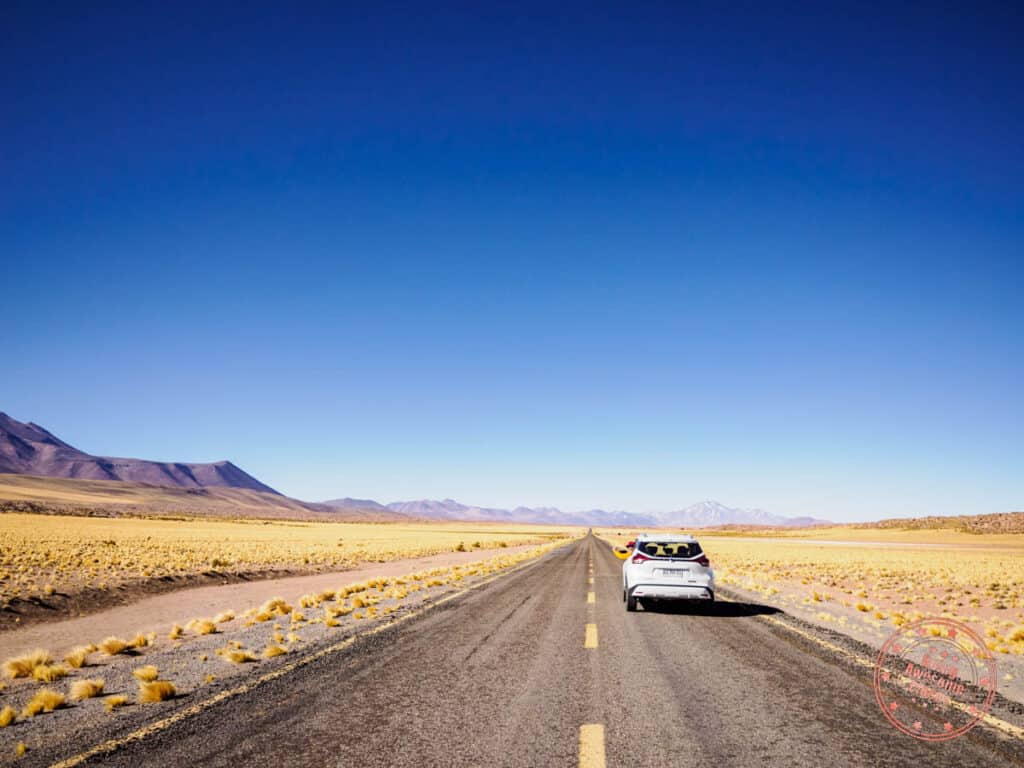
Day 1: Seeing The Clearest Night Sky
With no direct flights to the Atacama Desert, the easiest way to get there is via the largest town in the region, Calama and the El Loa Airport (CJC). There are multiple flights a day from Santiago (SLC) so you can decide how early or late you want to go.
TIP: If Atacama is your first destination in Chile and you have a short layover in Santiago, look at purchasing a prepaid Entel SIM so you can have this sorted and activated. You can do this in San Pedro de Atacama but you’ll have to spend time to find it.
Once you landing in Calama, you’ll head to the car rental counter in the main hall of the airport that’s outside of security. There are several booths here including Europcar and since they are undermanned, there might not be someone there. Look for a phone number and call it to let them know you’re waiting.
The cars are right in the parking lot in front of the airport and from there you’ll take the main highway that connects to San Pedro de Atacama. This is a 1 hour and 17 minute drive on a newly paved road.
On this drive, you’ll be steadily climbing in elevation, peaking at 3424 meters (11,234 feet). This means that you might start feeling the altitude en-route. For reference, Calama is 2,260meters (7415 feet) San Pedro de Atacama is 3,159 meters (10,364 feet).
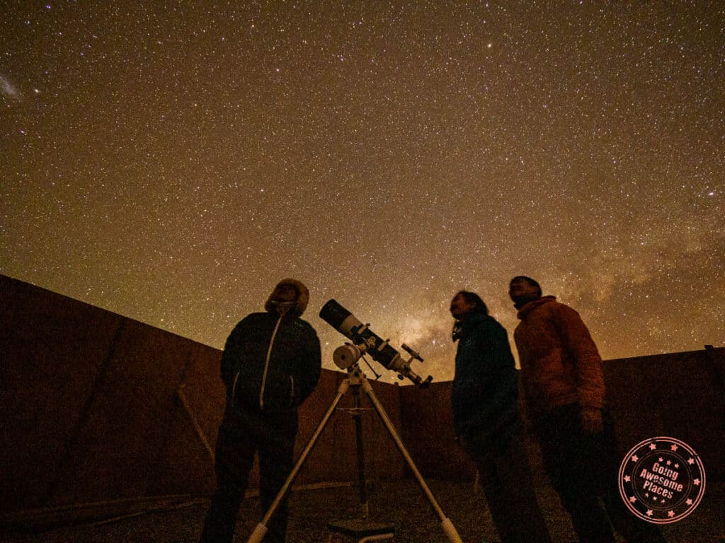
Settle into your hotel and get organized for your evening stargazing activity. It will get quite cold at night so prepare your layers, gloves, and toque/beanie. The property we stayed at and would highly recommend is Hoteles Pueblo de Tierra.
Have dinner at Sol Inti in town before getting back to your hotel to await your pick up.
PARKING TIP: If you’re looking for parking in town, know that Caracoles is a pedestrian street. The best parking spots are marked on our map with the first option being the best street parking in the heart of town.
For your first night in Atacama, we highly recommend that you book an evening with Jorge of Atacama Desert Stargazing. This tour splits your time between a class that’ll go through the history of astronomy with stargazing using several high magnification telescopes. Even if stargazing isn’t your thing, you’re going to be blown away.

Atacama is one of the best places for stargazing because of its altitude, lack of humidity, and clear skies. Throughout the tour, you’ll see numerous celestial bodies up-close with the most impressive being the Tarantula Nebula, NGC-253, NGC-104, Jupiter and its moons, and Saturn with its rings.
WHAT YOU NEED TO KNOW
Address: Jorge offers pick up at your hotel and will drive you to his house just outside of town.
Hours: This changes depending on the time of year. For our tour in September, our pick up was at 8:40PM.
Website: Atacama Desert Stargazing
Price: Traditional Astronomical Tour (TAT) is $100 USD, SAT 1 Special Astronomical Tour is $130 USD, and the SAT 2 Special Astronomical Tour is $180 USD per person.
What you’ll like about this activity:
- The first half of the tour is an astronomy class which is incredibly useful to have some background knowledge of its history, technical terms, how the equipment works, and specifics about the stars of the southern hemisphere.
- It’s impressive the number of telescopes he has in the yard where he conducts the stargazing. Even with a maximum size of 14, you’d only have 2-3 people per telescope.
- You’ll be amazed by how many star clusters, nebulas, galaxies, planets, and constellations he knows off the top of his head and how quickly he can locate them.
- The biggest flex is that he has a powerful enough telescope where you’ll be able to see the rings of Saturn and the spots of Jupiter upclose.
- There is no minimum for the tour so if you’re the only one that books it, you’ll end up with a private tour.
- The food offered on the tour is quite substantial and more than just a snack. It was almost like a full meal with small sandwiches, crepes, chips, cookies, guacamole, hot soup, and hot drinks. They have alcohol as well.
Tips:
- There are quite a number of astronomy tours in San Pedro de Atacama but if you’re looking for someone that is truly passionate about stargazing and has the knowledge and equipment to back it up, this is the tour to book.
- The term “Atacama Desert Stargazing” is quite generic which makes them hard to find. There are also many other products with similar names so don’t confuse them with Jorge’s.
- The tour names can be confusing between TAT, SAT 1, SAT 2, and others. The main difference between them is the stargazing time and how in-depth Jorge is able to get in his astronomy class. As a result, TAT is great for beginners, SAT 1 for those that want to go a bit more in-depth, and SAT 2 for advanced watchers.
- No matter what time of the year, it gets quite cold at night so be sure to wear a jacket, gloves, and toque/beanie. They have a portable heater and blanket but it’s best to have your own layers.
- This is not an astrophotography tour. While there is some time dedicated to it and Jorge can provide some guidance, this is definitely not his expertise.
- The tours do not run 3 nights before and after the full moon. As a result, it may be worth it to consider which dates you will be in the Atacama Desert.
- March to September (Chile’s winter) is best time for stargazing here.
- The time for the tour is an approximation. Using ours as an example, TAT 1 is only supposed to be 2.5-3 hours but we spent close to 5 hours with Jorge. He is quite generous with his time.
- No deposit is required upfront. You pay at the end of the tour and he accepts credit cards. Payment can be either in CLP or USD.
- For the photographers that want to do astrophotography, make sure to pack everything you need and have the settings prepared ahead of time. This part of the tour is quite short.
- A headlamp is helpful but not necessary. Use one that preferably has a red light so it doesn’t disrupt your eyes that have adjusted to the night sky.
- Avoid booking afternoon tours on the day of (in case they run late) and early morning tours the next day (this tour runs quite late into the evening).
- Try to book this tour on the first night of your trip because if it’s cloudy, you can reschedule it for a different day.
As a reminder for your Day 4 and 6 activities, make sure you book your Valle De La Luna tickets and Puritama online ahead of time if you haven’t done so already.
Day 1 Summary
What you’ll do:
Where you’ll eat:
- Dinner – Sol Inti – Traditional Chilean restaurant in San Pedro de Atacama with generous portions and is well-priced.
Where you’ll stay:
Tips:
- SIM Card: If Atacama is your first destination in Chile and you have a short layover in Santiago, look at purchasing a prepaid Entel SIM so you can have this sorted and activated. You can do this in San Pedro de Atacama but you’ll have to spend time to find it. We recommend Entel because they have the best reception in Atacama.
- Cash: It’s a good idea to have a mix of US Dollars and Chilean Pesos in Atacama. Hotels booked through Booking.com have to be paid in USD to avoid the 19% tax. Tours will accept both but often quote in USD. Entrance fees are typically in CLP and some locations don’t accept credit card. Tipping is also easiest with cash.
- Fill up nightly: There aren’t any gas stations outside of San Pedro de Atacama. A smart habit to get into is to fill up the tank of your car rental nightly or every morning before heading out.
Looking for the full Atacama itinerary?
Simply subscribe to be an Insider and get access to the 6 day Atacama itinerary in an easy-to-use and copy-able Google Spreadsheet will be given to you right away in this box. Submit your e-mail and the download link will appear right in the form. You’ll also be enrolled in the weekly flight deal newsletter!
Day 2: Brilliant Flamingos

Start your morning with the included breakfast at Hoteles Pueblo de Tierra.
Since we don’t recommend drinking tap water in San Pedro de Atacama due to its high mineral content, you’ll want to make sure you have enough water. One of the cheapest places to pick up water is at the local Supermercado Ketal. A 6L jug is $1,950 CLP. Stock up anything else you might need including snacks for the car.
Fill up your car at the COPEC gas station before heading out.
The main highlight of the day is Laguna Chaxa which is best known for its large population of flamingos that live here.
Belonging to the larger Atacama Salt Flats, this area is actually a depression in the land between the Andes and Domeyko mountain ranges where over the many years, minerals washing down from the mountains settled here to create a massive salt deposit.
Superficial lagoons have formed here where brine shrimp have thrived in waters with high mineral concentrations with high temperatures and low oxygen. This is very similar to the salt lake we’ve visited in our Northern California road trip which included a visit to Mono Lake.
The key is that birds including flamingoes love feeding on the brine shrimp in the shallow puddles of water, which is why there are such large colonies of them here.
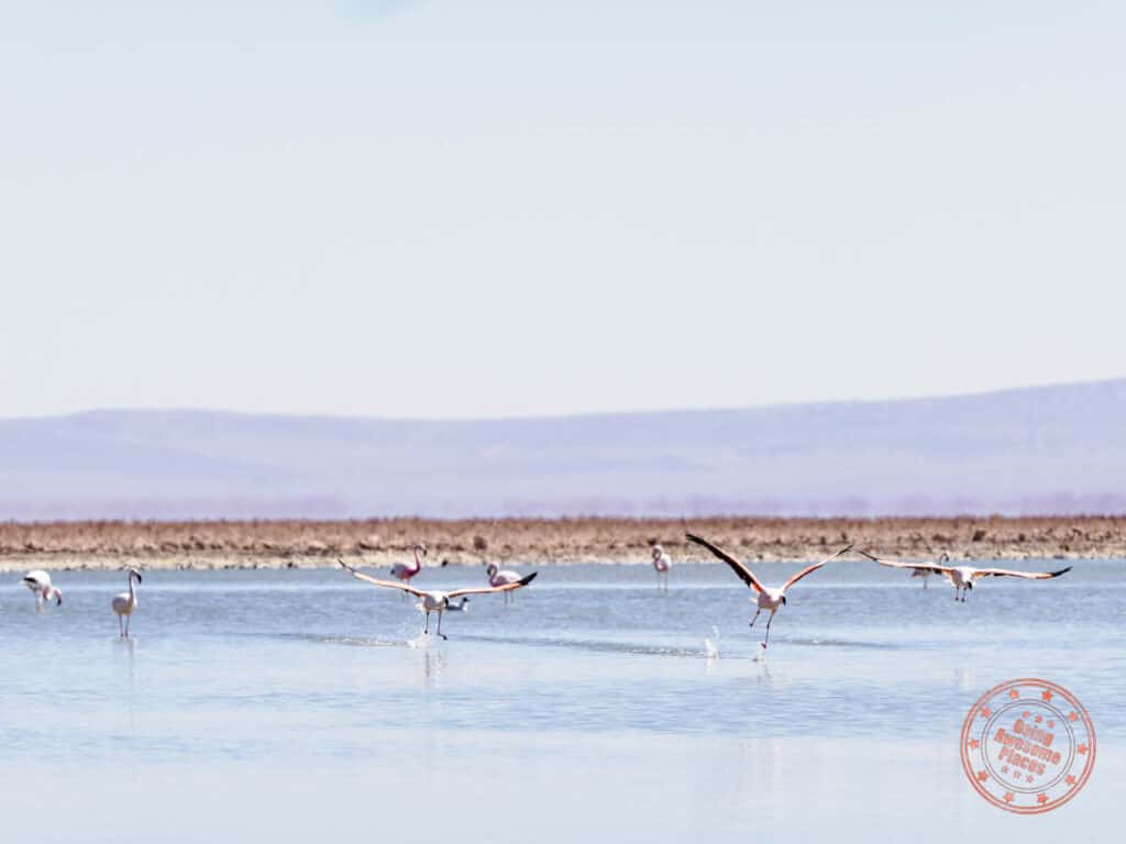
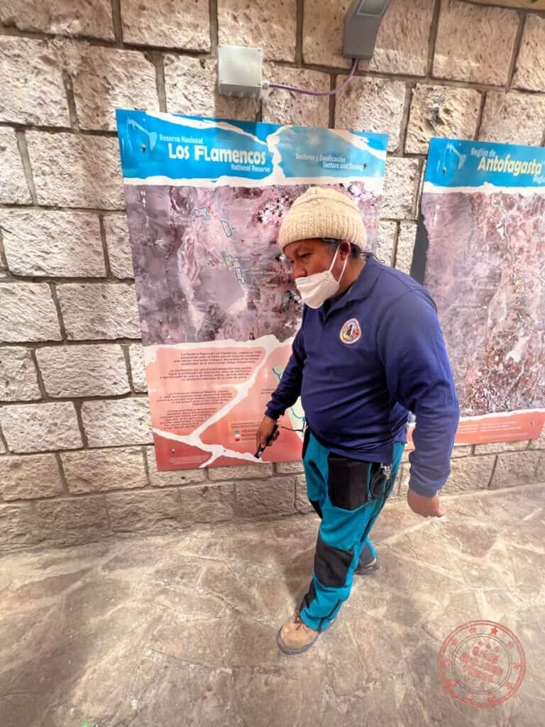
For your visit, you’ll start off with an information session where a guide will go through a few of the informative boards, examples of brine shrimp, and also how flamingoes start with white feathers and eventually turn pink through their diet. This part is only in Spanish but is mandatory because they need to explain the rules.
You’ll then walk a one-way trail that takes you along a journey along the dry salt flat, with various stops along the way that talk about brine shrimp, volcanoes and hills, and the salt lagoons. This trail leads towards an open area right in front of the lagoon where most of the flamingos are.
If you want to head straight to the flamingoes, there’s also a 2-way trail that goes from the visitor center to the lagoon.
WHAT YOU NEED TO KNOW


Address: On Google Maps, search “Laguna Chaxa Park” and not “Laguna Chaxa”. As you’re driving, make sure to be on the lookout for these signs as aids. The brown signs are the ones on the main highway which unfortunately don’t stand out very well.
Altitude: 2,300 meters (7,546 feet)
Length: 400 meter (1/4mi) trail that should take approximately 45 minutes. If you’re doing photography here, expect to spend 2 hours here.
Hours: This changes depending on the time of year. When here in September, this park is open Monday to Sunday from 7AM – 5:30PM. Currently, according to CONAF, the hours are 8AM – 1PM and 2PM to 6PM with last admission at 5PM.
Website: Community of Toconao and CONAF
Email: [email protected]
Price: For foreigners, the prices are $8,000 CLP for adults and $4,000 CLP for children 17 and under, and seniors >60.
How to pay:
- At the gate – The traditional way to pay is to go into the container building by the gate. They will take your names, age, country, and phone number. After you park, you then hand the paperwork to the ticket booth to grant you entry into the park. It does not look like they take credit card.
- Online – A new feature is the ability to pay for tickets online. There are no extra processing fees but you do have to pick a specific time and date to visit. The advantage though is that you can pay by credit card.
Facilities: At the visitor center area, you’ll find bathrooms and a terrace with picnic benches. There are no facilities once you head out on the walking path.
Tips:
- Reserva Nacional Los Flamencos (Los Flamencos National Reserve) comes up in many guides but it’s never clear where it is. This isn’t a specific place you visit but a group of areas designated as a reserve that includes Laguna Chaxa, Lagunas Miscanti y Miniques, Valle de la Luna, and Aldea de Tulor. These are spread all over the vicinity of San Pedro de Atacama and is not one contiguous park. This is why we don’t really mention Los Flamencos because it adds to the confusion.
- Toconao is at 2,485 meters (8,153 feet) so altitude should not be an issue here.
- There is no cover here so make sure to have a good hat, sunglasses, sunscreen, and plenty of water.
- We still recommend that you pay at the entrance instead of online just so you don’t have to lock in on a specific time slot.
- This is a fantastic location for photographing flamingos. However, due to the hours of the park, you likely won’t be able to capture them at sunrise or sunset.
On the way back, you can visit the town of Toconao. While there isn’t a tremendous amount to see, it’s still worth a quick pitstop to their quaint town square. Their main attraction is the bell tower that was built in 1750 made of three stacked sections of volcanic stone and faced with white stucco.

You’ll no doubt be hungry so head back into town to have an early dinner at Adobe. Located on the main pedestrian street of Caracoles, they are pretty low key in the late afternoon but turn into quite the lively restaurant with their fire pit and live music at night. It’s a great atmosphere with delicious mix of traditional and Italian dishes under an open-air courtyard.
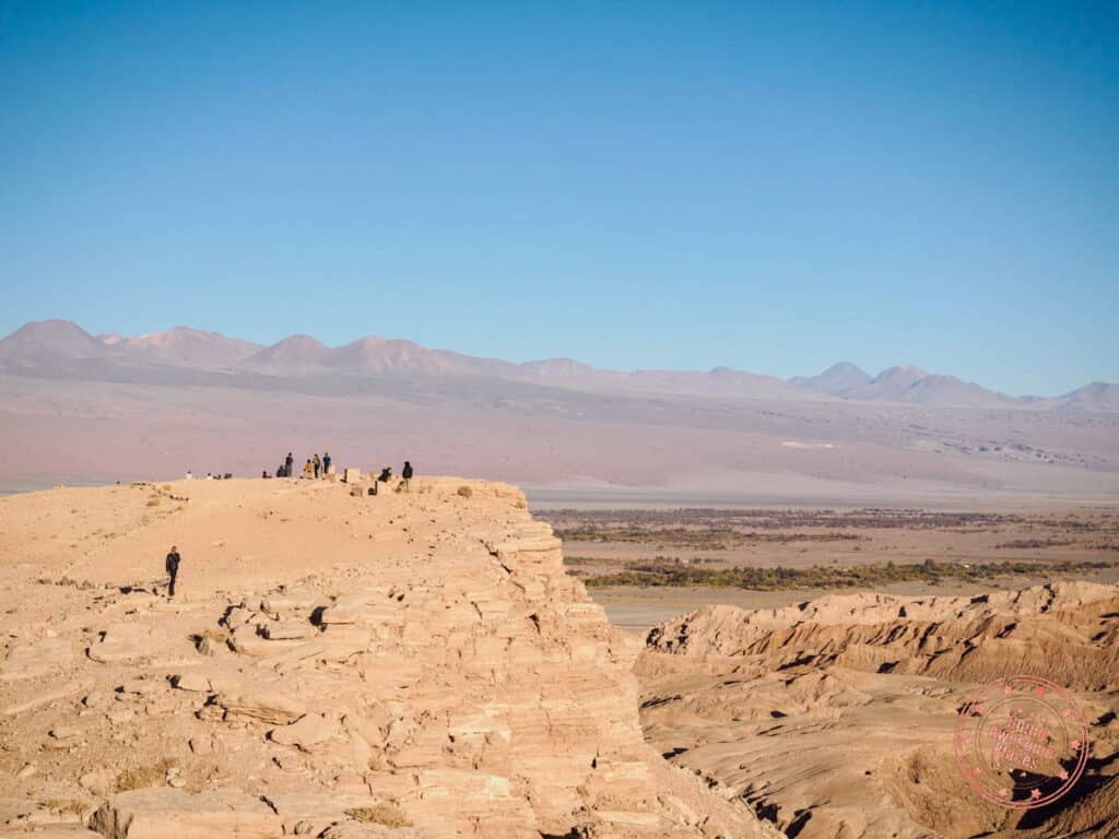
For sunset, you’re going to want to head to the most popular spot in town called Mirador Lickan-Antai. When you arrive, you’ll notice that there isn’t a proper parking lot as it’s literally off the side of the highway.
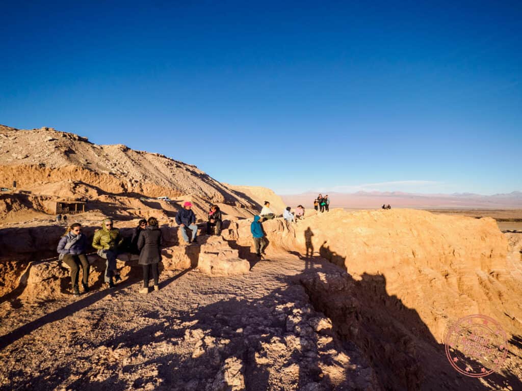
Once parked, you’ll cross the rocks to eventually get to an edge that has an elevated perched view of Valle de la Luna. The way the golden sun casts shadow on the dragon-like spine of the rock formations and deserts below are truly mesmerizing.

There’ll be quite a few people here so plan on arriving 30-40 minutes ahead of sunset.
Before you head home, remember to fill up your tank so you’ll be ready to go tomorrow.
Day 2 Summary
Driving time: The drive from San Pedro de Atacama to Laguna Chaxa Park is 1 hour.
What you’ll see:
- Laguna Chaxa
- Toconao
- Mirador Lickan-Antai
Where you’ll eat:
- Breakfast – Hoteles Pueblo de Tierra (eat a large late breakfast)
- Lunch – Snacks in the car
- Dinner – Adobe – One of the more popular restaurants in the most central part of town with high quality food and lively atmosphere.
Where you’ll stay:
Tips:
- Be careful with Google Maps – It’s critical to make sure you punch in the right location in Google Maps before setting out to Laguna Chaxa.
- Cellular signal – If you have an Entel SIM, you’ll have signal about halfway to Laguna Chaxa but afterwards it cuts out. If you bought tickets online, make sure you have it printed or take screenshots on your phone.
- Don’t underestimate the sun and heat – We highly recommend that you wear a thin and breathable long-sleeve shirt like the Outdoor Research Echo Hoodie.
- Effects of altitude – While you won’t be doing anything at very high altitude, you may still feel something especially overnight. For instance, I had pretty vivid nightmares for the first 4 nights although the tingly fingers that I had in Cusco during our 2 weeks in Peru never materialized. Be prepared for it and stay very well hydrated.
Day 3: Famous Altiplanic Lakes
For your third day, you’ll climbing up in altitude to visit magical lagoons of the mountains.
After a hearty breakfast at the hotel, you’ll be hitting the road again. We recommend that you start early to give yourself time to explore and take photos because there’s a 4.5 hours of driving just to get there and back.
Today, you’ll be going the same direction as the previous day but you’ll keep going and you’ll be climbing in altitude. What’s significantly different though is how scenic this drive is. Instead of flat desert plains with formations in the distance, you’ll start seeing more vegetation, wildlife, windy roads, and volcanic mountains.
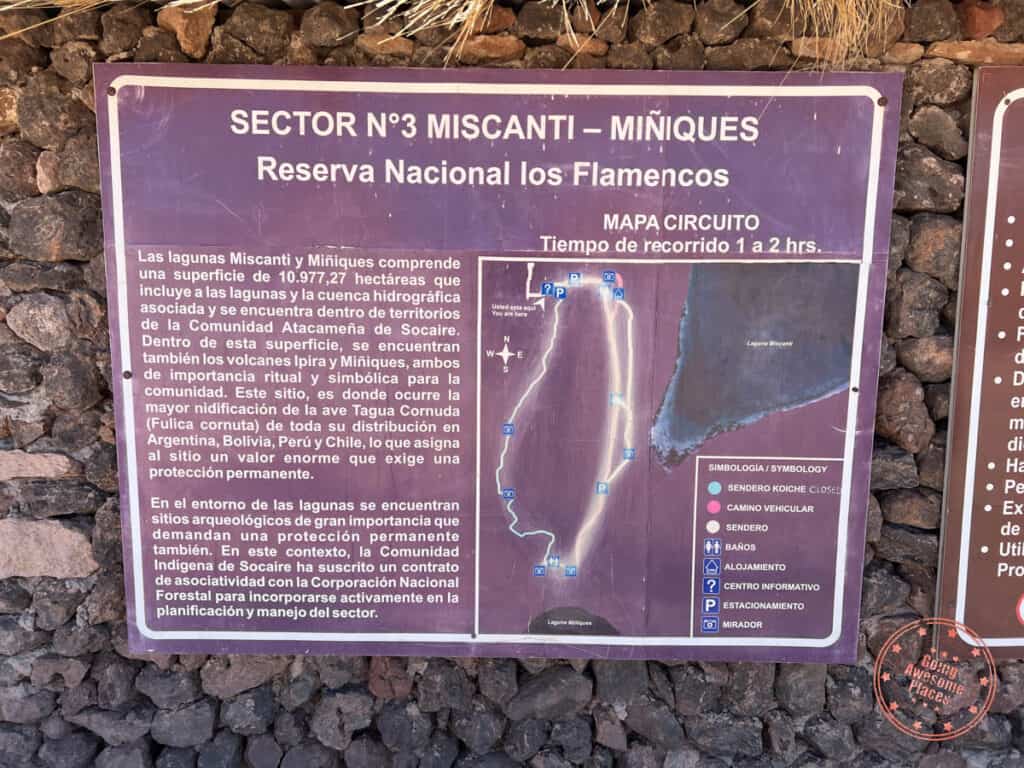
Your main mission is to see the Altiplanic Lakes which include the Miscanti and Miñiques lagoons which are side-by-side and also Piedras Rojas which is at the edge of Aguas Calientes Sur salt flats. Altiplanic comes from the Spanish word altiplano which means “high plains” and refers to a plateau that is predominantly in Bolivia but also cuts into Peru and Chile. It’s worth noting that all of these places are part of the Los Flamencos Natural Reserve.

Enjoy the drive and don’t be afraid to safely stop on the side of the road for photos. Also, be on the lookout for vicuña, an even cuter cousin to the alpaca. With their long lashes, fluffy wool, and smaller size, they’re certainly the cutest of the llama family.
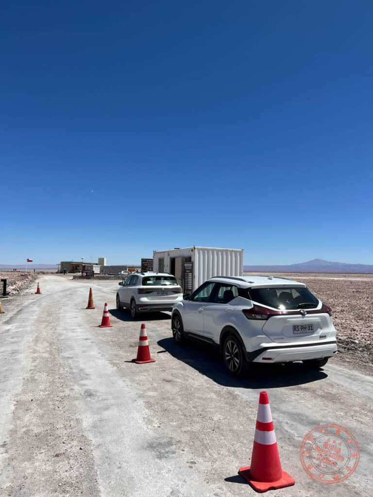
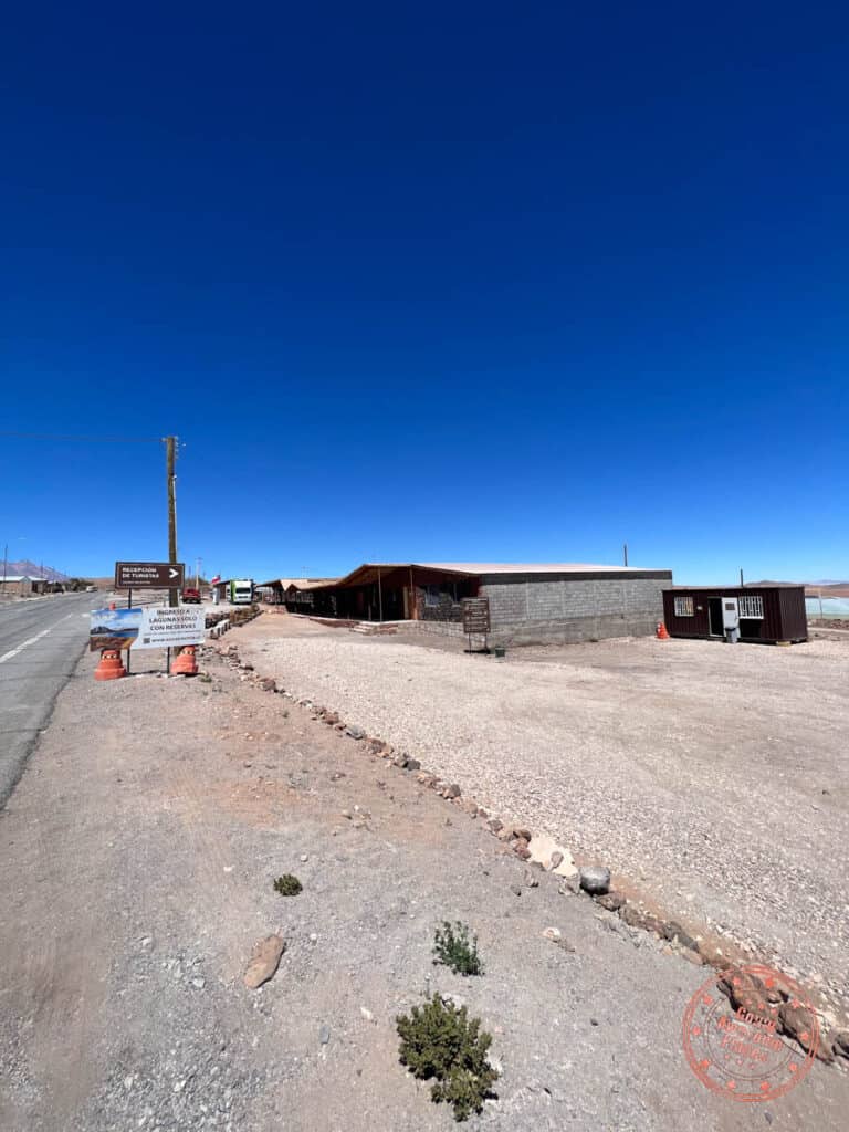
Your first stop is the town of Socaire and is an administrative one. Near the entrance of town is a brown container building which they call Recepción de Turistas. This is where you will show your online reservation, register your information, and pick up your official entry ticket. We recommend that you buy the ticket that starts at Piedras Rojas and ends with the Miscanti and Miñiques Lagoons.
WHAT YOU NEED TO KNOW


This part can be extremely confusing so we’re going to take care to explain it all.
Address: On Google Maps, search “SOCAIRE CHILE“. It has a green tree pin. This is the brown container you need to go to in order to register and pick up your tickets.
Ticket types: The ticket that you want is the ticket called “Southern Hot Water Salt Flats + Miscanti and Miñiques Lagoons”. This means that you’ll be doing Piedras Rojas first and then the twin lagoons. They also offer “Miscanti and Miñiques Lagoons + Aguas Calientes South Salt Flats” which simply means the other way around. Yes, this means the order matters. You can also purchase tickets to the individual attractions if you only want to do one.
Time slots: In addition to the order mattering, you’ll be forced to pick a time slot to register. For the combo tickets, there’s 9AM, 11AM, 1PM and 3PM. You have to check-in 1 hour before the slot. This means arriving at either 8AM, 10AM, 12PM, or 2PM. The 3PM slot is not available on Thursdays.
Hours: The hours for the twin lagoons and Piedras Rojas are 9AM to 6PM.
Website: Community of Socaire and CONAF
Email: [email protected]
Price: For foreigners, the prices for the combo of the two attractions are $15,000 CLP for adults and $13,000 CLP for children 5-17, and seniors 61+. Infants up to 4 years old are free.
How to pay: You can purchase the tickets online which allows payment by credit card. Note that there may be an additional fee if paying by MasterCard (read our Atacama travel guide for more details). After receiving your reservation number, you also need to fill out a passenger form which includes your passport number, e-mail, nationality, phone number, and accommodations.
Rules: They require visitors to register and pick up their tickets an hour before their time slot and you have to visit the attractions in the order that you selected. You also are not allowed to buy tickets in person nor do they accept cash. Lastly, the online passenger form must be filled out.
Registration steps: Once you arrive at the container, there’ll be 1-2 staff inside to help you.
- On a piece of paper clipboard, you will fill out each person’s name, passport, age, e-mail, and nationality. This step may be removed with the introduction of the online form.
- You will receive a small paper ticket with your reservation number.
Our personal experience: We had no idea this was a thing and was totally caught off-guard when we were ready to pay for our entry to Piedras Rojas because that’s how it worked at Laguna Chaxa. To our surprise, they said no and ended up getting another tourist to translate their Spanish. We were told to buy the tickets online. Of course, you can’t buy tickets for the same day online so we had no choice but to try our luck at the office which is 1 hour backwards. With no cellular data, we couldn’t find what turned out to be a tiny brown container and had to ask a local for help. Luckily, we were allowed to buy tickets for the day of and with cash, all of which are not allowed according to the website. This whole ordeal ended up being a frustrating 2 hour detour.
Facilities: There are no facilities in the container or surrounding it. There is a large gravel parking lot and that is it.
Tips:
- It’s honestly hard to tell how strict they will be with the rules that they’ve set forth since they bent it for us but to make sure you don’t have any surprise on your trip, it’s best to follow them.
- To avoid this step completely, you can book this tour with a company instead since they are responsible for acquiring the tickets and filling out all of the forms.
- There is cellular signal in the town of Socaire but once you leave, it quickly dies off.
Past Socaire, the drive becomes even more spectacular as you climb in altitude and you’re presented with wondrous mix of pastel-coloured lakes and contours of mountains that don’t look real.

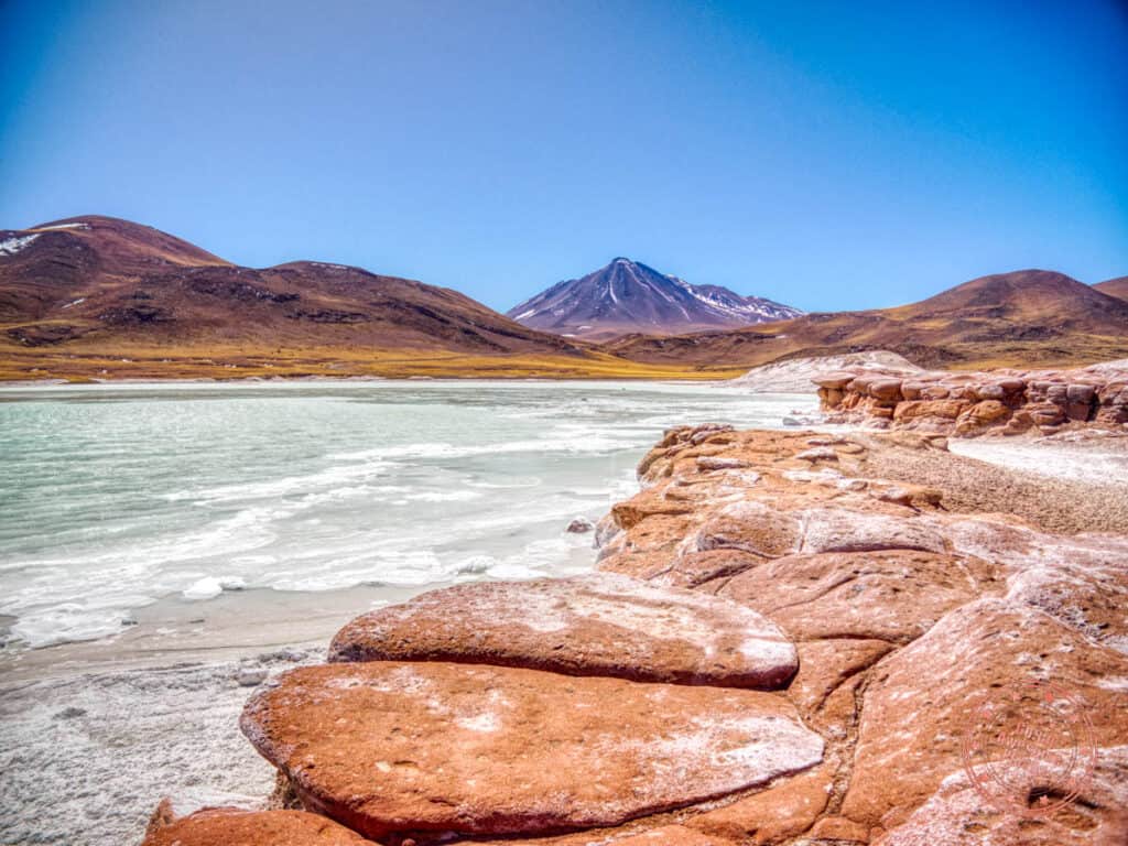
The first main sightseeing stop is a small viewpoint on the side of the highway which overlooks Piedras Rojas and Aguas Calientes.
Once you get to viewpoint for Aguas Calientes, you’re at more than 4,000 meters (13,123 feet) above sea level. This is when you will start feeling the effects of altitude sickness. While driving you may feel all of a sudden quite sleepy. Any walking you do will feel unexpectedly more difficult, requiring you to take more breaks and catch your breath. Take it slow and drink lots of water.
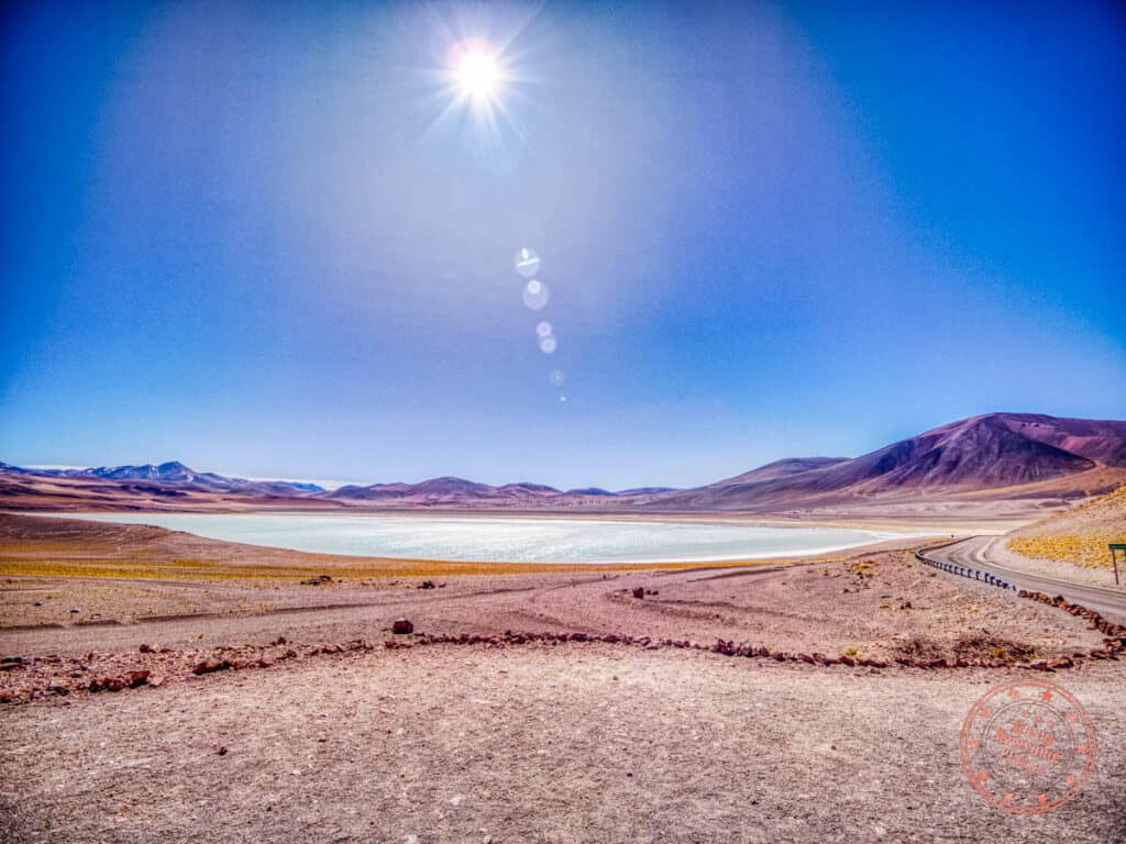
We recommend that you drive past Piedras Rojas and head out to the farthest point you want to go first. Eventually you’ll encounter a viewpoint for Tuyajto Lake. This is a beautiful light turquoise salt lake to admire.
You can continue driving past the viewpoint but I wouldn’t go past the small parking lot that we’ve marked on the map. Since it’s quite flat here and you can’t get close to the lake, the viewpoint is really your best spot. Driving any further will just take you to the border with Argentina.
Working your way back, the next stop is also off the side of the road and is easily missed. It’s marked as Mirador de Aguascalientes where there’s a path up to an amazing view of the entire salt lake from eastern side. It can be incredibly windy up here but worth the short walk up here as it’s likely you’ll be able to see flamingoes and vicuña below.

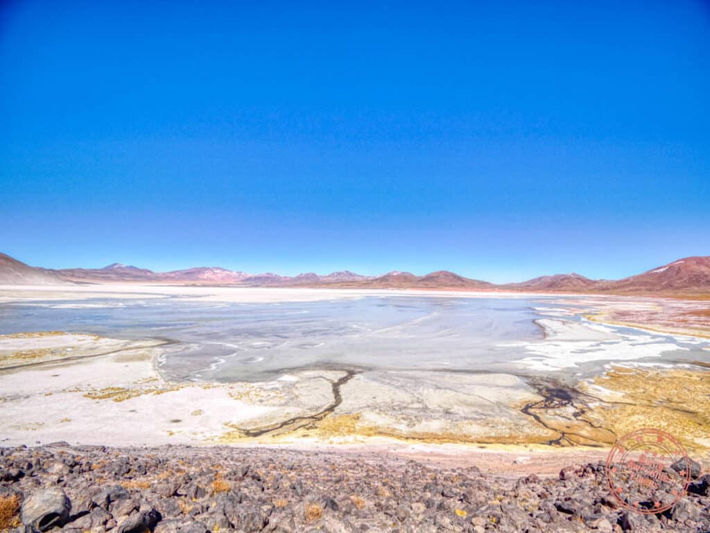
You’ll finally arrive at Piedras Rojas. In Spanish this means “red rocks” and this is a breathtaking trail loop that takes you all the way out to unique copper-colored rocks formed from oxidation of iron.
It’s quite the sight to see these rounded and peculiar rocks are juxtaposed against the edge of Aguas Calientes which looks like a sheet of ice covered by jagged crystals of ice but is in fact salt.
You might be blown away by the intense wind but you’ll be guaranteed to be blown away by the impossibly pastel-rich hues of the rock, lake, and surrounding volcanic mountains.
WHAT YOU NEED TO KNOW
Address: Google Maps points to the red rock formations itself which is next to the lake but the visitor center is immediately off the highway and not a specific pin. That said, you are fine to use “Piedras Rojas” for navigation because it is pretty close. We’ve marked the visitor center accurately on our map.
Altitude: 4,000 meters (13,123 feet)
Hours: 9AM to 6PM
Duration: Expect to spend 1 to 1.5 hours here.
Facilities: There are 2 bathrooms at the visitor center building but neither with running water. Only one has a toilet seat and the other does not. One is also accessible. There are no facilities once you get on the walking path.
Tips:
- At the ticket booth, you’ll show them your ticket. They’ll write something on the back and hand it back to you. Make sure to keep the ticket because you’ll use it again at Lagunas Miscanti y Miñiques.
- Before you start, someone will come out to guide you in what looks like a janitor’s closet to show you a tiny model of the area. The main emphasis is that it’s a loop trail and it only goes one way. There are no plaques anywhere at this site.
- The one way trail eventually leads to being able to walk on the red rocks themselves. This area is more open and you can freely walk around but be careful at the edges and you are also not allowed to walk onto the salty edges of the water. There is a guard standing watch in this section.
- This might’ve just been the specific day we were there but it was insanely windy to the point that it was inducing headaches and pushing us around so make sure you have the proper jacket, fleece, and headwear in the car in case.
- Make sure to pack water since there isn’t a lot of cover from the sun and altitude sickness will be in play.
- This is a bit of a longer trail loop and with altitude, you’ll feel quite fatigued and out of breath so take a slow and steady.
- Another name for the lake is Salar de Aguas Calientes and Aguas Calientes Sur.
- Remember that in Socaire, you picked up tickets for specific times where you have to go to the office one hour before. That said, I can’t see the Piedras Rojas office being particularly strict about when you arrive there because it’s an hour drive from Socaire and they don’t specify time slots at each location. There’s no need to stress about timing once you have your ticket. Just do it in the order in which your ticket says because they seem to care about this.
- Be on the lookout for vicuña and flamingos here.
The second part of your ticket is a visit to the highland lagoons of Miscanti and Miñiques. These are two large crystalline lagoons next to each other and consist of several trails and viewpoints.
Each lagoon is incredibly serene and calm with the mountains and sky reflecting off the water as birds including flamingos basking and looking for food.
WHAT YOU NEED TO KNOW

Address: Google Maps is accurate for this attraction. Simply search for “Lagunas Miscanti y Miñiques“. The signage for the turn off from the main highway is also quite clear.
Altitude: 4,200 meters (13,780 feet)
Hours: 9AM to 6PM
Duration: Expect to spend 40 minutes to an 1 hour here as it’s mainly quick photo stops at each viewpoint that can be reached by car. You can definitely do it faster if you just go to the main viewpoint for each lake.

Facilities: There are bathroom facilities at both Miscanti and Miñiques Lagoon. You can drive right up to the bathroom at Laguna Miscanti and park there.
Tips:
- On the rules sign, it says no drones are allowed.
- At the entrance, the gate will be down and the guard will raise it when you arrive. Hand the ticket over. Since this is the final destination, they will be keeping it.
- This same guard will take you to the signage with the map and rules. They will explain where the bathrooms are, the parking areas, and that the “Sendero Koiche” trail is closed.
- The main rules to pay attention to are that you are not allowed in the water, you can’t picnic here, there’s no smoking, and you cannot fly drones in this area.
- On the topic of drones, while there aren’t no-drone signs everywhere, it’s safe to assume that you aren’t allow to fly it in any of the major sights.
- At 4,200 meters (13,780 feet), the altitude effects will be noticeable so take it slow and stay hydrated.
- Similar to Piedras Rojas, the wind can be quite strong so be prepared with the right layers.
- While there is a trail you can take for Laguna Miscanti, it did not seem worth it. With parking lots on both ends of the trail, it is much easier to drive to each side, snap photos, and move on.
- There is only the viewpoints from the parking lot at Laguna Miñiques so it is a relatively quick stop. Note that the parking lot is not marked on the map but you are allowed to drive up there now.
- There are some flamingoes here but definitely not in the number that you’ll see at Laguna Chaxa.

As you drive back towards San Pedro de Atacama, you can make a quick stop at the official Tropic of Capricorn line. There’s a parking lot here and you can walk up to the triangulating poles that’s part of a much larger Camino del Inca.
Back in town, roam around town, dropping by the booths set up around Plaza de San Pedro de Atacama and large souvenir markets such as Feria Artesanal San Pedro de Atacama.
Treat yourself to a hearty dinner at Pizzería El Charrúa. This joint is always packed with people so we suggest coming here earlier to grab a table. which is always packed with people.
Sleep early because you’ll be waking up at 4AM.
Day 3 Summary
Driving time: The drive from San Pedro de Atacama to the furthest lake (Tuyajto Lake) is 2 hours and 15 minutes.
What you’ll see:
- Tuyajto Lake
- Mirador de Aguascalientes
- Piedras Rojas
- Lagunas Miscanti y Miñiques
- Tropic of Capricorn line
- Plaza de San Pedro de Atacama
- Feria Artesanal San Pedro de Atacama
Where you’ll eat:
- Breakfast – Hoteles Pueblo de Tierra
- Lunch – Snacks in the car or you can try to catch Cocineria Santa Barbara in Socaire if it aligns with your timing.
- Dinner – Pizzería El Charrúa – Popular pizza joint in town that has now expanded to two locations right across from each other. Their family-sized pizzas are perfect for two.
Where you’ll stay:
Tips:
- Pin all locations – Before you head out, make sure you’ve saved the pins of all the locations for the day. As a back up, you’ll find some signal in Socaire if you have an Entel SIM.
- It gets cold and windy – You’d think the desert would just be hot and sunny but the reality is that it’s actually mostly windy and cold. Have your jacket, layers, hat, and gloves ready. We’re not kidding when we say that the wind knocked us around. Remember to check out our Atacama packing list (coming soon).
- Be prepared for the altitude – Most of the day will be at 4,000 meters (13,123 feet) or above. This affects everyone differently. For my wife, she got incredibly sleepy on the drive from Socaire and onwards. Any walking we did felt like we had bricks on our legs and our lungs shrunk to half capacity.
Day 4: From Geysers to the Moon

You’ll be combining two of the must-do’s of any itinerary to the Atacama Desert with bursts of water in purple light with moonscapes glowing in fiery hues.
Set your alarm for 4AM and aim to get out of your hotel by 5AM.
Geyser del Tatio (El Tatio Geysers) is the largest geyser field in the southern hemisphere and third largest in the world. With 80 active geysers, water temperatures at 85°C (185°F) will bubble up to 75 centimeters (2.5 feet) and if you’re lucky, they’ll shoot up 6 meters (20 feet).
The drive up to Geyser del Tatio is just over 1.5 hours but it’ll test your driving abilities as it is a windy road in the dark where most of it is bumpy gravel that’ll require some skill and patience. The tour vans will likely pass you but just stay the course.
It’s a magical place early in the morning because this is when the geothermal activity is the highest. An ethereal steam blankets the floor while the geysers burst with water while also creating large plumes of cloud.
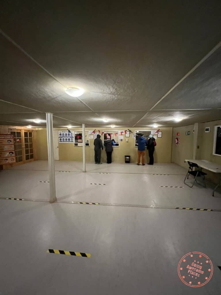
When you arrive at the main gate, you’ll be provided some instructions to park in the lot, head over to the visitor center building to fill out the passenger form, pay the cashier, and get your ticket and map. This is also your chance to use the bathrooms.
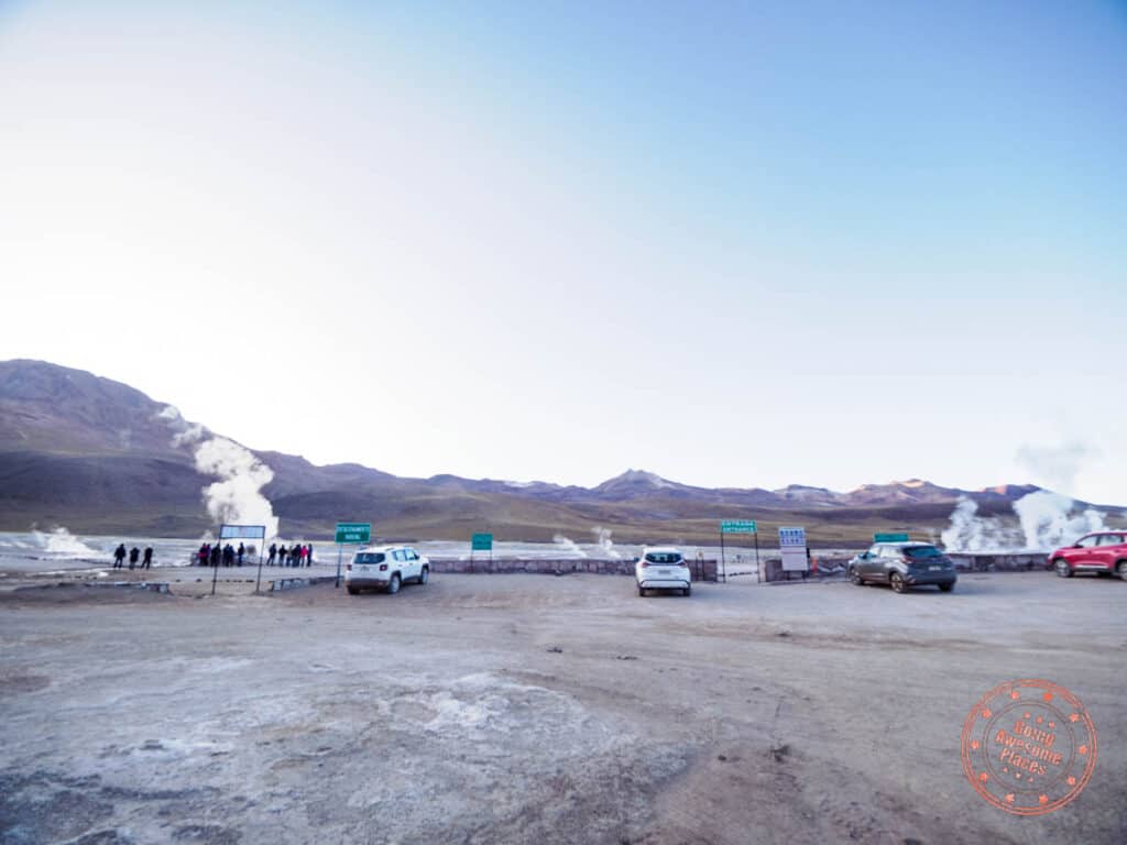
Pass through the second gate with your ticket and drive all the way to the farthest point where there are geysers with the most activity. At this point, the sunrise will be in its early stages.
Walk out on the designated paths and look out for the geysers with larger thermal activity. It’ll be pretty clear which one is the “Great Geyser” as this will have the largest radius. The geysers you will see here are a mix of vents on the ground, mud pools, and geyser cones.
You’ll also notice some mechanical equipment in the field. The story is that a company tried to tap into field for energy was abandoned because of environmental impacts and drilling altering the behaviour of the hot springs.
After you walk through the main area of geyser activity, hop back into your car and park in the adjacent lot. This is to save you a bit of walking and give you access to another set of geysers. It is connected with the first so you can also walk here if you’d like. At this point, the sun will be out and the blue and purple hour will be over.
The final section of the park is back near the entrance with a thermal pool and additional viewpoints for more geysers.

If you’re up for it, you can use the change rooms and jump into the hot springs in your bathing suit. Fed from the geothermal activity below, you swim around and soak in the mineral rich water, similar to Blue Lagoon in Iceland but way less glamorous.
By the time you’re ready to leave, the geyser activity will have died down although not as dramatic as people make it sound.
WHAT YOU NEED TO KNOW
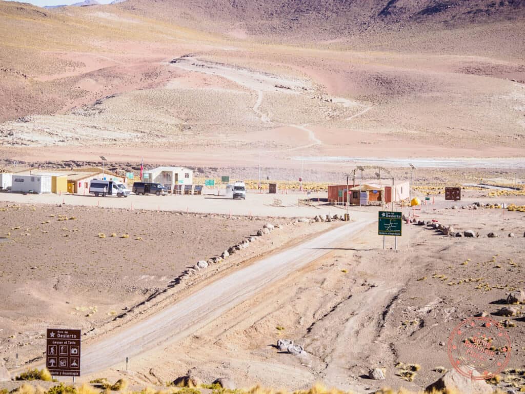


Address: Both “El Tatio” and “Complejo Turístico Tatio Mallku” on Google Maps will take you the right way. Along the way, you’ll pass through several small villages. The lights from the tour vans ahead should help give you an indication that you’re going the right way.
PAltitude: 4,320 meters (14,173 feet)
Hours: 6AM to 4:30PM
Website: There is none that we could find.
Price: For foreigners, the price is $15,000 CLP per person. You can pay by cash or credit card and they will charge you in CLP.
Duration: Expect to spend 2-2.5 hours here. If you’re going into the hot springs, add more time.
Facilities: There are bathrooms near the front gate and also in the parking lot next to the hot springs pool.


Tips:
- While locals will tell you that the drive is treacherous, it is not bad as it sounds. There are some stretches that are either paved or decently flattened while the bumpy parts require care around a few dips and potholes. There aren’t many real blindspots on turns to worry about either. The car will be shaking because of the uneven gravel but you’ll be fine.
- You’ll also be pressured to keep up with the tour vans but let them pass and instead, follow the path they take on the road for easier driving.
- The form you need to fill out requires your name, passport number, phone number, and vehicle information.
- This is at high altitude so be aware that you will feel more fatigued and lose your breathe as you walk. Take it slow and make sure to have water with you.
- Since this is early in the morning, expect the temperatures to dip below freezing. In our case, it was -7°C (19.4°F) so have your winter gear with you (jacket, fleece, toque/beanie, and gloves).
- You don’t necessarily need to arrive right when the park opens. Instead, plan to arrive when the sun starts to rise.
- The park will be swarmed with white tour vans. In the main geyser field parking lot, there’s easily 10+ of them lined up to give you sense of how many people are there in the morning.
- There is surprisingly 3G cellular signal at Geyser del Tatio.
- If you’ve been to geothermal sites in say New Zealand, Iceland, or Yellowstone in the US, go in with tempered expectations as the geysers don’t shoot up into the sky (Iceland’s Strokkur Geyser erupts up to 20 meters/65.6 feet versus 6 meters/20 feet) to give you an idea of the difference. There’s quite a bit of bubbling activity and once in awhile it might go up a bit higher but these aren’t dramatic geysers.
- It’s widely accepted that the only way to see Geyser del Tatio is to go in the morning which is when geothermal activity is the strongest.
- The natural hot springs was not open in September when we were there. The pool was fully drained out. It’s possible that it has yet to be open because of the pandemic.
- If you’re planning on going to the hot springs, make sure you have your bathing suit, change of clothes, and towel.
- Since it’s such an early morning, ask your hotel whether it’s possible for them to prepare a packed breakfast.
Contrasting to the darkness of your drive in, you’ll be able to see the surrounding mountains, lakes, flora and fauna, and birds that inhabit the nearby area.

There is also one lookout point along the way back that’s worth stopping at that has a gorgeous panoramic view of the landscape, and tour vans creating large plumes of dust.
Halfway back, you’ll pass by the village of Machuca. You’re free to stop here to visit the local church and fresh llama kebabs if they’re on the grill. You might also see flamingoes along the river that flow through here.

The bizarre thing that happened to us passing through Machuca was that there was someone from town that stopped all the cars coming through to provide us with a piece of paper with rules for the village including no flying of drones, not taking photos of residents, only taking photos from the side of the road, and not disturbing the wildlife. Since we didn’t understand their Spanish, it was hard to tell whether they were welcoming us in or if they wanted to make sure we obeyed the rules. We simply nodded and kept driving.
You might be feeling a bit tired after such an early morning start so feel free to head back to your hotel to nap.

Arriving back in San Pedro de Atacama, head over to Emporio Andino for lunch. They’re a cosy cafe with plenty of tables inside. Their empanadas are some of the best in town as well so we recommend that you also take a few to go so you can nibble on them at sunset.

Valle de la Luna (Moon Valley) is where you’ll spend the rest of the afternoon in. This is a massive park that has quite a number of key areas to visit so you’ll want to make sure you have enough time.
What makes Valle de la Luna so special is how spectacularly otherworldly it is. With its geological formations that could easily be on the moon, Mars, or Arrakis from Dune.


While the ticketing system and what’s open and closed can be quite frustrating and confusing like most of Atacama. Here are the sites within the park that are currently opened. Everywhere else is closed to visitors:
- Duna Major – This follows a huge ridge in the valley that has towering views of the saw-tooth crusts that rise from the barren dessert, walls of rounded red rock, mazes of canyons, and a picturesque dune of fine sand.
- Victoria Mine – An old salt mine with examples of machinery, dwellings, and access to the underground. You won’t be able to enter inside.
- Tres Marías – A trio of rock spires that’s located at the far end of the park that’s accessible to the public.
Another impressive view is the Amphitheatre which is an impressive wall of sand, clay and salt resembles the exterior wall of the Roman Colosseum. This can be seen from Duna Major and also up close as you drive on the main road.
WHAT YOU NEED TO KNOW

Similar to Altiplanic Lakes, visiting Valle de la Luna without a tour is not as straightforward as you think.
Address: The visitor center for Valle de la Luna isn’t marked on Google Maps because it is quite new. We have it in our own map but on the app, you’ll want to search “Alojamiento Haramaksi Atacama” which is right next to it.
Altitude: 2,520 meters (8,268 feet)
Hours: Sunday to Friday 9AM – 7PM (last entry is at 4PM). Closed on Saturday.
Website: They don’t have an official website but Chile Travel has good information.
Price: For foreigners, the price is $10,000 CLP for adults and $5,000 for seniors, university students, and kids 12 and older when you buy the ticket online through Punto Ticket (similar to a Ticketmaster). It is imperative that you purchase your tickets online ahead of time because they can actually sell out of time slots. You must change the language to Chilean Spanish or Español chileno, otherwise it won’t work.
Duration: Expect to spend 2.5-3 hours here based on the 3 attractions that are open right now. If you move quickly, you can do Duna Major’s longer trail in an hour and the shorter trail in 30 minutes. Victoria Mine is a quick 15 minutes. Lastly, Tres Marias is a quick photo stop unless you want to get in line for a photo right in front.
Facilities: There are bathrooms at the visitor center. We did not see any bathroom facilities inside the park.

Check-in process: At the visitor center, you’ll check in with the QR code on your online-purchased tickets and they will explain on a map what’s open, the rules of the park, and also give you a separate ticket for the sunset viewing at Mirador de Kari & Piedra del Coyote. Afterwards, you leave the center and do a self-guided drive of the park.
Frequently asked questions:
- Can you buy tickets on the day of? No you can’t. Make sure you buy your tickets online ahead of time.
- How does the sunset work? You might think that you can watch the sunset from inside Valle de la Luna and in the past it was. You used to be able to watch it from Duna Major but instead, sunset viewing is at the combined lookout called Mirador de Kari (sometimes referred to as Ckari) and Piedra del Coyote (sometimes referred to as Mirador Coyote).
- Where is the Magic School Bus? This is a spot that’s mentioned a lot by other guides and while it looks like it’s part of areas accessible in Valle de la Luna, it isn’t. There is an unmarked road that can lead you to it. If you’re interested, you can follow this map to the Magic Bus.
- Why is the ticket page for Valle de la Luna blank? There’s a strange bug on their website which I’ve let them know about and this appears when you’re browsing from outside of Chile. You must change the language to Chilean Spanish or Español chileno, otherwise the page won’t work.


Tips:
- When planning your trip, make sure you don’t put this on a Saturday.
- Recommended to buy your tickets at least a week in advance to make sure the slot you want doesn’t sell out. Worst case, make sure to do it the first day you arrive in the Atacama Desert.
- It is unclear if in an emergency, you can buy tickets on the day of. All of the information out there says no so I would not bank on this.
- Valle de la Luna is at a significantly lower altitude so you won’t feel it as much as the Altiplanic Lakes.
- The best time to visit Valle de la Luna is in the afternoon so you can combine it with sunset at Mirador de Kari & Piedra del Coyote.
- The drive to the park and within is quite easy in comparison to Geyser del Tatio and Lagunas Baltinache.
- The hiking trail for Duna Major has two different routes. When you reach a fork in the path, left is the longer way around which has a much better view of the canyon. The path on the right takes you straight up and connects with the view of the desert dune. A heads up that the longer path is not great for those with vertigo because you’ll be right up at the top of the ridge which has drops on both sides. That said, the path is quite wide so it’s manageable and worth it because it’s honestly the best view in the park.
- All hiking trails are designed to be one way paths with no doubling back. For those that are self-driving this means that you won’t finish the hike at the original parking lot. You’ll have to take a walking path along the main road back to your starting point.
- They noticeably enforce the rules more than anywhere else in Atacama Desert. The tour guide vans will call you out on it (in our case, yell at you) and park rangers will stop you to give you warnings. Here are the ones to pay attention to:
- Make sure to stick to the 40 km/h speed limit. The truth is, they really expect you to drive 20 km/h as we were warned by the park ranger.
- Do not walk on the road and stick to the walking paths.
- Don’t remove any natural minerals for souvenirs.


After you finish exploring Valle de la Luna, you’ll have exclusive access to a new sunset viewing spot that’s adjacent to Mirador Lickan-Antai. This location is actually two viewpoints in one and called Mirador de Kari & Piedra del Coyote (Kari Viewpoint & Coyote Stone).
The difference with Mirador Lickan-Antai is that that it has a better view of the valley floor of Valle de la Luna and is at slightly higher elevation, thus providing a better birds-eye-like view.
Mirador de Kari is on the left and to the right is Piedra del Coyote. After you scout the area and pick your favourite spot, you’ll be able to watch the sun set behind the mountain range in the distance.
WHAT YOU NEED TO KNOW
This is an extension to Valle de la Luna but there are several details worth breaking out.

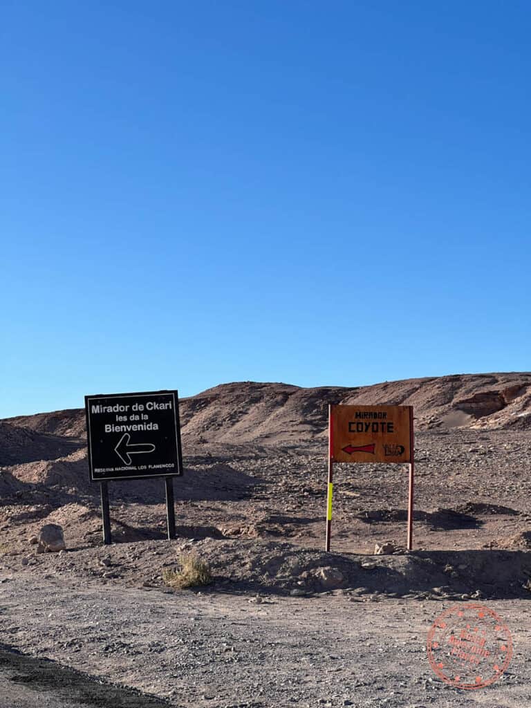


Address: On Google Maps, it’s correctly marked as “Mirador de Kari – Piedra del Coyote” so it should be easy to find. It is also right off of the main road. There is also good signage here, marking the location.
Altitude: 2,580 meters (8,465 feet)
Hours: For sunset, there is a strict last entry time provided by the Valle de la Luna visitor center. As an example, in September this time is at 6:45PM (marked on our map) but will change throughout the year. Remember that this is closed on Saturday.
Price: This is included for Valle de la Luna ticket holders and valid for the day you visit.
Duration: The sunset times will change throughout the year but from the last entry time to when they kick people out, you’ll have roughly 45 minutes. After everyone applauses when the orb of the sun disappears, they will expect you to clear out.
Facilities: We did not see any bathrooms here so it’s a good idea to use them at the Valle de la Luna visitor center on the way out.
Check-in process: After you turn into the viewpoint, there will be a small building with a guard there. They will take the ticket and you’ll be allowed to proceed to look for a parking spot.
Frequently asked questions:
- Can you stay for the full sunset? They will only allow you to stay until when the sun dips below the mountains and you can no longer see it anymore. At this point, the staff will start ushering people to leave.
- Is Mirador de Kari or Piedra del Coyote better? For more views of the open valley floor, Piedra del Coyote is better. If you want to be closer to thejagged ridges, Mirador de Kari is better.
- Are tripods allowed? Yes.
- Can you visit Mirador de Kari & Piedra del Coyote separately to Valle de la Luna? No, you can only come here with the purchase of Valle de la Luna tickets on the same day.
Tips:
- Make sure to plan enough time to drive from Valle de la Luna to the sunset viewing point. It will take 15 minutes from the visitor center.
- There are parking spots at both Mirador de Kari (left) and Piedra del Coyote (right).
- Mirador de Kari and Piedra del Coyote are connected so you can walk from one end to the other.
- For a better view of the valley floor, we recommend Piedra del Coyote. For a view that’s similar to Mirador Lickan-Antai with jagged and layered canyons, go to Mirador de Kari on the left.
- Between here and Mirador Lickan-Antai, we wouldn’t say that this is significantly better. You’ll notice that the chain that prevents people from getting too close to the edge is quite conservative (for good reason) so it’s quite hard to get a photo without the cliff in the foreground.
- If you’re a photographer, try to work quickly to identify a specific spot you want to photograph because it gets crowded quite quickly. The edges will fill up with people and it’ll be hard to relocate so it’s best to camp out one spot.
- It’s really unfortunate that you won’t be able to stay for proper real golden hour since they kick everyone out so early. Mirador Lickan-Antai is your better bet for photos.

After sunset, have dinner at one of the best restaurants in San Pedro de Atacama. Baltinache Restaurant elevates Chilean dishes in both preparation, modern cooking techniques, and presentation. Refreshingly targeting a refined dining audience, their focus in quality over quantity is evident in their 3-course menu for $23,500 CLP.
If you happen to be in town on a Friday night, make sure to check out the local night market (marked on our map). They have food stands, carnival games, and dance clubs.
Friendly reminder to gas up!
Day 4 Summary
Driving time: The drive from San Pedro de Atacama to Geyser del Tatio is 1.5 hours. The Valle de la Luna visitor center is a short 10 minutes drive from town.
What you’ll see:
- Geyser del Tatio
- Valle de la Luna
- Mirador de Kari & Piedra del Coyote
Where you’ll eat:
- Breakfast – Snacks in the car or packed breakfast
- Lunch – Emporio Andino – Popular cafe in town with a great selection of coffee, cakes, sandwiches, and empanadas.
- Dinner – Baltinache Restaurant – An affordable high-class restaurant with a superb 3-course menu that will easily be one of your best dining experiences in Chile. Reservations recommended during high season.
Where you’ll stay:
Tips:
- Don’t be scared of the drive – While Atacama seems to be geared towards taking tours, take confidence in knowing that many people have successfully done it independently with a rental car. The drive up to Geyser de Tatio is not as bad as people make it out to be.
- Book tickets online – I know we’re beating a dead horse here but make sure to buy your Valle de la Luna tickets online in advance and remember that they are closed on Saturday.
Day 5: Floating On Water

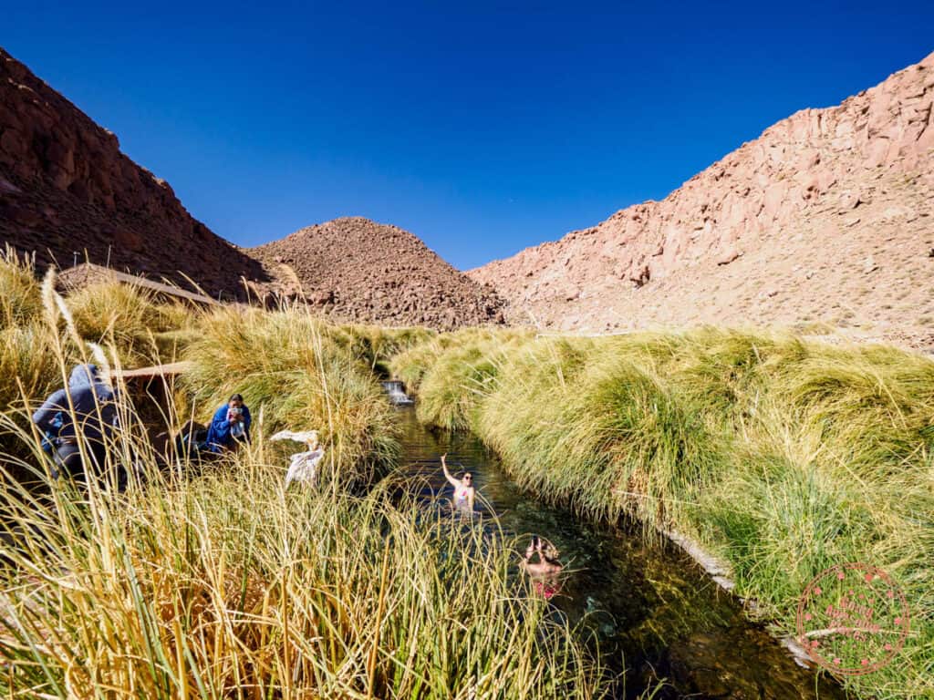
After a busy 4 days in the Atacama Desert, you’ll take an easier pace by getting to the more relaxing portion of the trip. With so many salt flats and lakes, you’ll get to do the unique activity of floating in the hidden lagoons of Baltinache.
You deserve a break and so we suggest that you sleep in and have a late breakfast at Hoteles Pueblo de Tierra which goes until 10:30AM.
With all of your gear in the car, set out for a very bumpy drive out to the Lagunas Baltinache (Baltinache Lagoons). Like the other attractions in Atacama, they will tell you it’s not recommended to drive there but it’s very much possible.
After a 1 hour and 15 minutes on a constantly rumbling gravel road, the facilities of the lagoon will pop out of nowhere like an oasis.

Dazzling with crystal clear turquoise and surrounded by snow-like salt and mysterious bumps in the ground, there are 7 salt lakes here that can be explored by two main parking lots and a boardwalk that connects them.
The surreal landscape is enhanced by the ability to enter 2 of these lakes where the extreme salinity allows your body to float when you’re in the water. It’s a similar experience to the Dead Sea except here, you’re in a much smaller lake that’s surrounded by a desert landscape.
WHAT YOU NEED TO KNOW


Address: Lagunas Baltinache is similar to Laguna Chaxa in that you have to look up a specific name on Google Maps to go to the right place. You have to search for “Lagunas Escondidas de Baltinache” and not simply “Lagunas Baltinache” because that pin is completely wrong. The main highway you’ll be taking is B-241.
Altitude: 2,349 meters (7,707 feet)
Hours: 9AM – 6PM
Website: They don’t have an official website unfortunately.
Price: For foreigners, the price is $10,000 CLP for adults and $5,000 for kids 5-18. This is a fixed rate throughout the day.
Duration: Expect to spend 2-3 hours here.

Facilities: There are bathrooms at the entrance area. Currently it looks like they are trying to build a new structure. At the moment, there are no proper change rooms so you’ll need to resort to the bathroom stalls. With the renovation, there are also no showers.


Check-in process: Once you get to the first gate, similar to Laguna Chaxa, you’ll have to walk into the container building to fill out a form and pay. The form asks name, passport number, phone number, and car information. Once you’ve paid, there’s another building adjacent to the container where a guide will explain the rules of the park including pointing out the key areas on the map. This orientation is mainly in Spanish but they’ll try their best in English if they can. After that, you get back in your car and drive either to the parking lot for the first lagoon or the furthest and larger lagoon in the back.
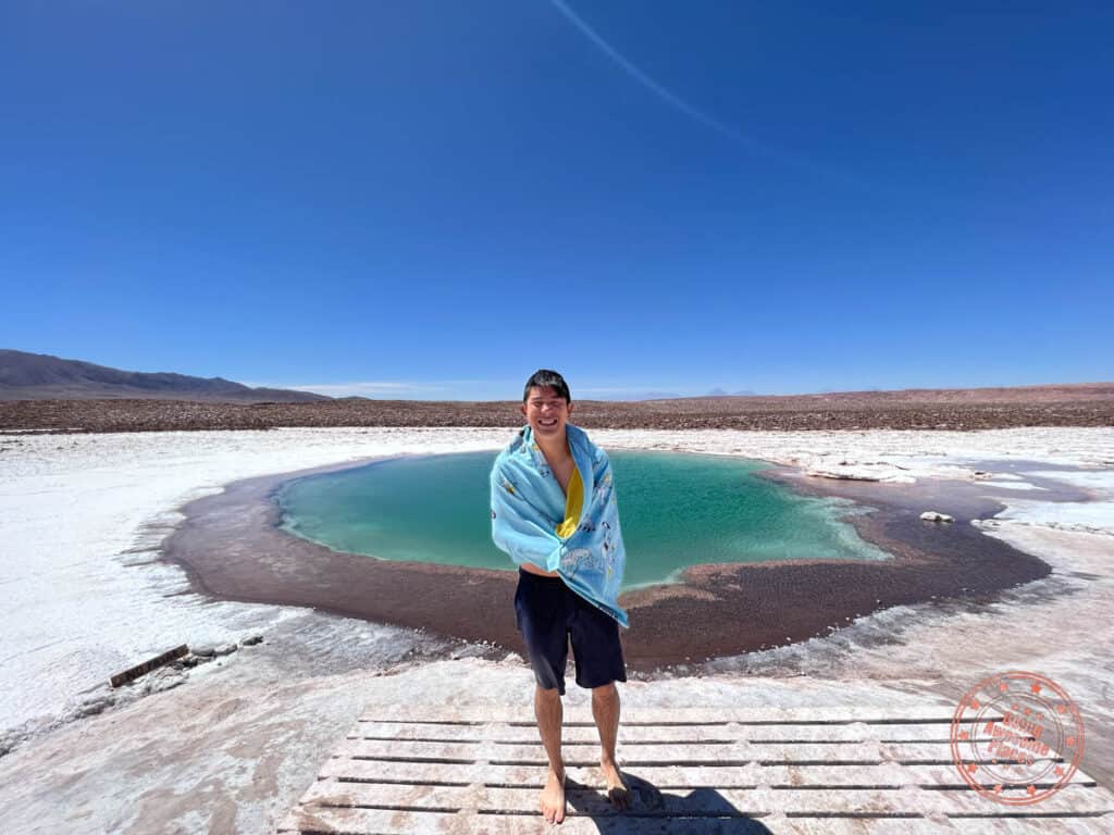
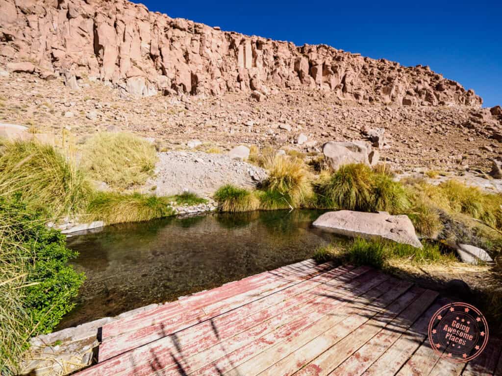
Lagoon #1 experience: This is the smaller lake that’s closer to the entrance.
- Smaller in size and fits less people comfortably.
- Most photogenic lake where with wide angle, you can be captured as the only person in the lake.
- A much more pleasant experience because there are 7 picnic tables with umbrellas. This allows you to lay out your clothes and gear for quick access.
- There is a large wooden deck above the rocky surface which makes it easier to get into the lagoon
- The edge of the lake is encrusted with rock and salt that can give you cuts but if you walk carefully, it’s not an issue.
- The outer part of the lagoon is not deep so that’ll allow you to enter the water first. The turquoise part of the lagoon is where it gets deeper.
- When you come out of the lake, you’ll start feel the salt crusting over your skin and will eventually turn white.

Lagoon #2 experience: This is all the way in the back and reached to by a long boardwalk from the parking lot. You can also walk to here on the boardwalk that connects from Lagoon #1.
- A larger lagoon that is set up more like a traditional beach where there’s a wide and gradual entry into the water .
- There aren’t any picnic tables here so you’ll be putting your things on the rocks.
- This lagoon can fit a lot more people.
- It’s quite hard to get the full width of the lagoon in a photo.
- There is a much longer walk on the boardwalk to get back to your car.
- Overall, the first lagoon is a much better experience in our opinion.


Rules:
- Drones are not allowed.
- Don’t walk or sit on the edge of the lake.
- You’re only allowed to wash off in the parking lot by your car.
- Only put sunscreen on your face and not your body.
Frequently asked questions:
- What’s the best way to wash off the salt? You are only allowed to rinse off in the parking lot. With your bathing suit still on, use a large bottle or jug of water, rinse off your hair and try your best to rub off the salt off your body before it’s had time to crystallize.
- Can you buy tickets on the day of? Yes. You don’t need to make reservations online.
- When is the best time to go? There are bus tours that run throughout the day but from personal experience, there didn’t seem to be too many people here between 1:30PM – 3:30PM. A big batch of tours come in at around 3:30PM or 4PM. The park then gets quite again at 5PM so end of the day is a great time as well. Mornings are also quieter.
- Are drones allowed? No. They explicitly mention this in the briefing and there’s a sign for it as well.


Tips:
- It can be quite windy in this part of the desert so while it is very sunny, it can be cold. Since it is very windy, make sure the belongings you put on the ground or on the tables are secured.
- The water is not warm at all. At 20ºC (68ºF), it’ll be a bit of a shock when you first get in but on a hot summer day, can be quite refreshing.
- When you come out of the lake, it can be exceptionally cold especially with the wind blowing so you’ll want a towel that’s easily accessible.
- The advantage of coming on your own vs with a tour is that you’ll have more freedom to stay longer because most tours are limited to 1.5 hours. On your own, there’s also the chance to have the lagoon all to yourself.
- Don’t take off your sandals until you enter the water because the ground can be sharp. People have been known to get cuts. Definitely wear your shoes when walking on the trails.
- To make things easier, go there with your bathing suit already on and pack a full change of clothes, towels, sunscreen, and plenty of water for rinsing and drinking. Also pack a first aid kit in case someone gets cuts.
- Realistically, you won’t be staying in the water for as long as you think. Depending on the temperature, most people stay in for 10-20 minutes tops.
- Where most of the time goes is in drying off, warming up, rinsing off, and changing. There is also the board walk path you’ll be walking to see the other lagoons.
- Some won’t have a reaction to the high salt content but some may have more sensitive skin. It’s hard to tell if you’ll have a negative reaction to the salt unless you’ve done it before. If a rash or hives develops, use antihistamines if you have them or go to the pharmacy and ask for calamine lotion. If your skin starts hurting while in the water, get out.
- Avoid getting the water in your eyes. Try to swim with your head above water.
After your floating escape, drive back into town and it’s highly recommended to go back to the hotel to shower because the salt can be quite irritating.
For the rest of the evening, you’ll have another opportunity to explore the lovely vibe of downtown San Pedro de Atacama.
When you’re feeling hungry, head over to Ckunna, a restaurant located on one of the main streets and has a great combination of delicious Andean cuisine and Italian dishes.
If you’re up for dessert, we recommend Heladería Babalú. There are two locations in town and you’ll enjoy their unique flavors.
Don’t forget to fuel up the car before heading back home!
Day 5 Summary
Driving time: It’s a tough 1 hour and 15 minutes drive one-way from San Pedro de Atacama to Lagunas Baltinache.
What you’ll see:
Where you’ll eat:
- Brunch – A late breakfast at Hoteles Pueblo de Tierra
- Dinner – Ckunna – A typical restaurant in Atacama with a mix of meat dishes and Italian. They have a spacious outdoor dining space with fire pit and indoor tables as well.
- Desert – Heladería Babalú – The main gelato shop in town. There are two of these in San Pedro de Atacama.
Where you’ll stay:
Tips:
- Hwy B-241 is terrible – The road to Lagunas Baltinache is easily worse than B-245 to Geyser del Tatio because there are no good parts at all. The entire road was flattened by a machine that left a tank tread of bumps in the road so it’s a rumble all the way through.
- Drive fast – This will sound counterintuitive but the advice of driving 20-30 km/h in an effort to be careful doesn’t work well because you feel every single bump. By driving 60-80km/h, you’ll actually feel less of the road as the bumps somehow even out.
- Reduce tire pressure – At the gas station, it’ll also help to reduce the tire pressure to by 2 to 4 PSI. For instance the Nissan Kicks should be at 32 PSI. For gravel roads, you can bring it down to 28-30 PSI.
- Don’t cheap out on car insurance – When renting a car, opt for the insurance coverage just in case you end up with windshield chips or you have other issues with the car. We’re not saying that this road is treacherous but better safe than sorry.
Day 6: Puritama Oasis
For your final day of your 6 day Atacama desert itinerary, you’ll be pampering yourself with a true oasis in the middle of a desert canyon.
By now, you’re probably tired of the hotel breakfast so treat yourself to La Franchuteria, a bakery and cafe that brings France to the desert.
Locals come here to stock up on baguettes and a wide selection of artisanal breads but we recommend that you grab a seat in their outdoor dining space that has quite the free-spirited atmosphere. Their sandwiches, croissants, fresh juices, and coffee are superb.
At brunch, there’s usually live music playing (for donation) and local vendors with tables set up.
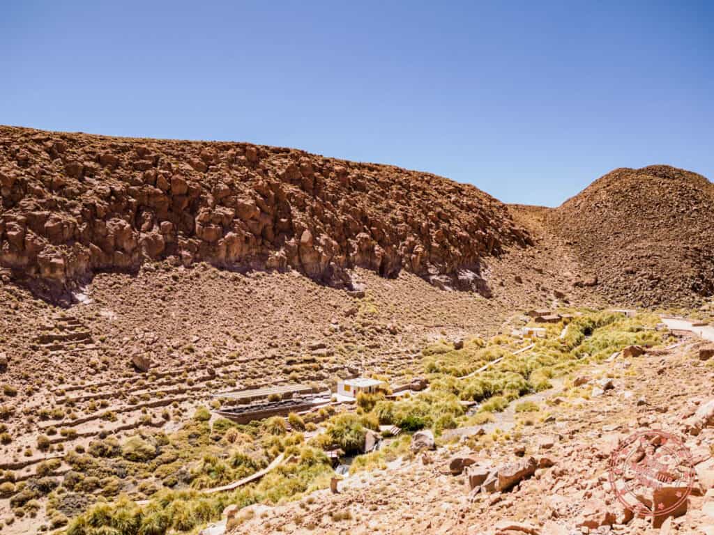
Next, you’ll start making your way up the same road that you would’ve taken to visit the Geysers del Tatio, the B-245 except you won’t be going as far. You’ll be well-accustomed to the roads at this point and you’ll be able to make it to Puritama Hot Springs in a quick 30 minutes.

Nestled in an Andean canyon is the Puritama Conservation Reserve where you’ll find the Puritama River. “Puri” meaning water and “Tama” means hot and for a 1 kilometer (0.6 miles) stretch, the river becomes naturally heated, slowly filling 8 natural pools carved into the rock.
Currently managed by the luxury hotel brand, Explora, you can book time slots to soak in the pools that are rich in calcium, magnesium, sodium and boron, which are recommended for recommended for rheumatism, arthritis, stress, physical fatigue and other ailments – just what you need after 6 days in the Atacama Desert!
Each pool is numbered from 1 to 8 and the water here ranges from 28°C (82.4°F) to 31°C (87.8°F), with the pools higher up being slightly warmer than the ones below.
WHAT YOU NEED TO KNOW


Address: The pin for “Puritama” or “Termas de Puritama” are accurate on Google Maps and will take you to the entrance gate.
Altitude: 3,475 meters (11,401 feet)
Hours: 9:30AM to 6:30PM
Website: Puritama
Email: [email protected]
Price: Children 3 years and under are free. Kids are children 4-12.
- 9:30AM – 12:30PM Slot – Adults $30,000 CLP, Kids and Elderly $15,000 CLP
- 2PM – 5PM Slot – Adults $30,000 CLP, Kids and Elderly $15,000 CLP
- 5:30PM – 6:30PM Slot – Adults $16,000 CLP, Kids and Elderly $8,000 CLP
Duration: Expect to spend the full duration of your time slot. A heads up that the sunset slot is only for an hour.


Facilities: There are two sets of change room and bathroom facilities spread across the hot springs. There is a central one that hot springs that pools 4-8 will use. There is another one that’s closer to pools 1-3. At the central central, there is also a large picnic area of tables and benches and are mostly under shade (9 in total).
- Bathrooms – Behind the change room facility are individual bathrooms.
- Change room – Divided between male and female. Inside are lockers and two benches. The lockers don’t have any built in locks and so you’ll need to bring your own.
- Picnic tables – 7 are under shade and 2 are exposed to the sun. These are modern concrete picnic tables that are bolted to the ground and are useful for those wanting a break from the hot springs to come up to hang out or grab a bite.
- Showers – There are no showers at Puritama.


Check-in process: If you arrive early, you’ll notice a mess of cars parked all around the gate. It’s a bit of organized chaos but right when your time slot starts, the gate opens and one by one cars turn in. The person in the booth will ask for the name on the reservation and after that, you’ll be let through. Drive up the gravel road to the parking lot. There’s plenty of space here. Follow the trail downhill to reach the hot springs. There won’t be anyone checking tickets or identification at this point.
Check-out process:
They’re not overly aggressive but the guards will make their rounds 10-15 minutes before to get people out of the pools, changed, and ready to go. At the end of your time slot, everyone will be expected to be making their way back to their cars.
Rules:
- No smoking
- No alcoholic drinks
- No drones
- No pets
Frequently asked questions:
- Are you allowed to take photos and videos? Yes, unlike some spas, there are no rules preventing this. In fact, most guests will be taking tons of photos at the pools so be courteous and help each other out.
- Which is the best pool? Having visited each one, our opinion is that Pool #5 is the most photogenic. It’s a medium sized pool that can fit 10 people and has waterfalls running over two large boulders on one side and has a nice ledge that cascades down to the next pool.
- Which is the largest pool? The most spacious pool that can fit the most people is Pool #2.
- Are you assigned a specific pool? Coming right out of the pandemic, you were forced to pick a pool number and there’d be a maximum number of people per pool. If you’ve read this, these were the old rules. Assigned pools are no longer a thing anymore.
- Can you try different pools? Now that the limits are on the whole hot springs themselves (100 for AM and PM, and 50 for sunset), as opposed to assigned pools, you’re free to try different pools.
- Can you buy tickets on the day of? No, you have to make reservations ahead of time and are most likely sold out for the day of but you might get lucky.
- When is the best time to go? The afternoon is the most ideal time slot because the sun will be out and you’ll feel less of a chill when you come out of the water.
- How hot are the pools? The water temperature ranges from 28°C (82.4°F) to 31°C (87.8°F) but there are no thermometers at the pools. Logic would dictate that the pools at the top (lower numbers) are hotter but in practice, when testing Pool #5 vs. Pool #8, we did not feel a ignificant difference. We believe the temperature range is more dependent on geothermal conditions and weather on the day of with slight variations pool to pool.
- Is there a place to put your belongings by the pool? There sort of is. Each pool has a wooden deck. Since most people elect to keep their belongings with them (i.e. their camera, phones, and towels), they’ll bring their backpack right to the deck and place it on the ground. There are no hooks or benches.
- Do most people stay in the pool for the entire time slot? Yes, the 3 hours actually goes by incredibly fast. While you’d think you’d want to take a break in between after your skin wrinkles up, the chill outside of the water makes you want to stay in the water the whole time.
- Can you have food and drinks by the pool? Technically, yes as there aren’t any rules that prevent this but it makes more sense to eat and drink at the rest area. That said, the staff don’t exactly make rounds at the pools and as long as you eat or drink in a respectful and sanitary way, it should be ok. Just remember that no alcohol is allowed.
Gallery of all 8 pools (click to open full screen):


Tips:
- We recommend reserving 1 week in advance.
- Show up 15-20 minutes ahead of your time slot so you can get checked in first. This means positioning your car right across the front gate. This will give you the most time in the pools and you’ll ha e a chance to take photos without people around you.
- If you’d like to use the locker in the change room, remember to bring a travel lock.
- The only pool that’s off limits is the VIP section of Pool #1.
- While over at a slightly higher altitude, it doesn’t have a noticeable impact except for the walk back up to the parking lot at the end of your session.
- Go in with a careful strategy of how you organize your belongings so that important items such as towels are easily accessible and phones/cameras can be safely put away.
- Even on a sunny day, it is quite a shock to the system when you come out of the water because of the temperature difference and how windy it is even in the canyon. Have your towel handy.
- For those that would rather take a van to Puritama, you can book a tour instead.

For dinner, you’ll eat at La Pica Del Indio, a restaurant with a fresh rotation of daily dishes, affordable prices, and great service. Feel free to try another restaurant that might’ve caught your eye or revisit one from the previous days.
Now you’re probably wondering, what about the part about leaving the Atacama Desert? Depending on your flight, you’ll be driving your car rental back to Calama. It’ll be a straightforward drive but remember to fill up in town before you go to the airport. This means pinning a gas station on your map app beforehand.
Day 6 Summary
Driving time: It’s a 30 minute one-way drive from San Pedro de Atacama to Puritama.
What you’ll do:
- Termas de Puritama (Puritama Hot Springs)
Where you’ll eat:
- Lunch – La Franchuteria – A French bakery and cafe that has serious hipster vibes in the best way possible with their alfresco dining, vegan-friendly menu, and rows of sycamore-like trees.
- Dinner – La Pica Del Indio – Super affordable restaurant with a great assortment of meat, fish, and pasta.
Where you’ll stay:
Tips:
- Book early – Like Valle de la Luna, you’ll want to book Puritama as early as possible because it is a very popular attraction in Atacama.
How You Could Tweak This Atacama Itinerary
There are so many different ways you can build a 6 day Atacama Desert itinerary. This is really just one way this trip can be done. With different interests and amount of time, you can change it up in any way that makes sense for you.
Here are a few alternatives that are worth considering:
- Book with tours – One of the obvious changes would be to go the traditional route and book the standard bus tours that they offer so you don’t have to worry as much about the finer details and the challenging driving. For those that want to book in advance, we recommend you check out Viator and GetYourGuide.
- Rainbow Valley – Yes, the Atacama Desert has its own version of Rainbow Valley. We opted not to go because we were warned that the Google directions weren’t very helpful. That said, it looks like a brilliant hike. The name to look for is “Valle del Arcoiris” and is close to the Yerbas Buenas Petroglyphs. We highly recommend that you get AllTrails and follow their trail map.
- Yerbas Buenas Petroglyphs – The number of petroglyphs that can be found here is staggering. This is located north of San Pedro de Atacama and near the town of Lican.
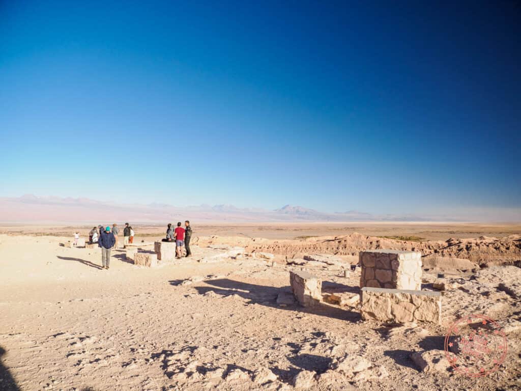
- Pukará de Quitor Castle – This is a pre-Columbian archeological site that overlooks the valley of the river San Pedro. Come here to see the ruins of a fortress that was used to protect local indigenous people from the Spanish conquistadors.
- Laguna Cejar – When it comes to salt lakes, there are actually quite a number to choose from but if you’re like us, you won’t feel like it’s necessary to see them all. Some say that this lake is a bit underwhelming but what’s unique about it is that you can swim in. Chances of seeing flamingos is also quite low here so it’s primary for swimming. The fee is $15,000 CLP.
- Laguna Tebinquinche – Another lagoon with an entrance fee ($5,000 CLP). It’s a large salt lake with some bird life but they don’t often come close to the shoreline compared to Laguna Chaxa. Note that this is a minute drive from Laguna Cejar and is often combined together.
- Bolivia – When you look at the map, you realize how close the Bolivia border is. You won’t be able to do it as a day trip but if you’re ambitious, there are ways to reach the Uyuni Salt Flats from San Pedro de Atacama.
- Sandboarding – Originally we wanted to do this but we found out from a local that Valle de la Muerte (also known as Valle de Marte) it was closed. Not having g the time to confirm this, we scrapped the idea. Also, in walking around San Pedro de Atacama, we didn’t see any tour operators promoting sandboard rentals. Ultimately, the only operator offering this is Sandboard San Pedro which is pricey but might be the only way to do it now as they take you to a secret sand dune outside of town.
- Hot Air Balloon – In the morning, you’ll see a number of hot air balloons rise in the sky. This is an affordable activity you can book.
- Biking – A popular activity in Atacama is riding a bicycle. You can rent them or you can choose from one of many cycling adventures like this e-bike trip to Laguna Cejar or going downhill on a volcano.
- Láscar Volcano Summit – You can do a full day hike up to the top of this volcano. Private trips up start at $200 USD.
Map of San Pedro de Atacama Desert Itinerary
The below is an interactive map broken down by layers for each day of the itinerary so you can see where things are in relation to each other in the Atacama Desert.
TIP: To create a copy of this map for your own use, simply maximize the map to open it up in a new tab. From there, go into the menu and select “Copy map”. You’ll be able to make your own adjustments and open it up in the Google Maps app as well.
5 Tips for Self-Driving in the Atacama Desert
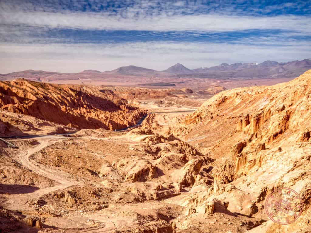
When we think about our car rental and driving experience in and around San Pedro de Atacama, there are 5 core learnings that we’d love to impart to you as you build out your own Atacama itinerary.
- Pin the right spots – The de-facto navigation app is Google Maps and while it only works when you get the location right. The Atacama Desert is notorious for deceiving pin locations so make sure you know the exact name. Luckily, we’ve made sure to be quite explicit about this at each location.
- Fill up every day – Remember that there is only the one gas station in San Pedro de Atacama and after our drama in Milford Sound, New Zealand, we learned not to take the chance. Get into the habit of filling up your tank every night.
- Check your tire pressure – Some rental cars have tire pressure sensors and some don’t. This is one of those things you normally don’t think about but with the tough road conditions, you’ll want to make sure you’ have good tire pressure every day as well. Luckily, the one and only gas station, COPEC, has a tire pump device that’s free.
- Altitude can hit while driving – Be aware of how you’re feeling when you’re driving on the day you visit the Altiplanic Lakes as you’ll be going through high mountain passes. Drink plenty of water and take a break if you a sudden wave of fatigue.
- Driving faster can be better than slower on the gravel roads – On flat and straight roads such as the one you’ll be taking to Lagunas Baltinache, you’ll initially want to drive 20 km/h but you’ll actually feel every single bump. By picking up the speed to 60-80km/h, you’ll have a smoother ride. It’s counter-intuitive. We recommend that you give it a try as you build more confidence.
For all of our tips for traveling the Atacama Desert, make sure to read our travel guide.
How Much Does This Atacama Itinerary Cost
For those that are considering renting a car, here’s an accurate representation of how much you’d expect to spend on a 6 day San Pedro de Atacama itinerary.
Actual itinerary costs
Here’s what we actually spent (prices are in USD) and for two people:
| Expense | Cost (USD) |
|---|---|
| Flight | $876.17 |
| Car Rental | $377.09 |
| Fuel | $139.55 |
| Hotel | $628.00 |
| Activities (i.e. entrance fees) | $432.68 |
| Groceries | $8.00 |
| Restaurants | $301.00 |
| Souvenirs | $70.00 |
| Tips | $45.00 |
| TOTAL | $2,877.49 |
The only thing that’s missing here is the Entel SIM card which I purchased in the Patagonia leg of the trip.
Trip cost per person = $1,439 USD
This breaks down to $240 USD per day per person. For reference, our 10 days in Egypt was $203.51 USD.
What would the cost be without a rental car?
That’s a big amount for 10 days but it may help to put it in perspective against other itineraries.
All else being the same and swapping out the rental car for tours, you’d be looking at booking these (USD, per person):
Note that tours don’t include entrance fees so we’re not factoring those costs here.
Total cost for 2 people comes out to $595.38 USD compared to $572.09 for the car rental, fuel, and Puritama entrance fee. That doesn’t even include tipping!
The costs are very similar so it really comes down to how comfortable you are with driving and whether you’d like the freedom to explore at your own pace, and overall flexibility.
Who Is This Itinerary For?
That leads to this final section about the ultimate type of traveller this Atacama itinerary is for.
This is the type of traveller this trip is built for:
- Seeks adventure and willing to try new things.
- Loves the thrill of exploring with your own car.
- While loving adventure, also looks for a balance of comfort, good food, and relaxation.
- Wants to have control of the itinerary as opposed to being led around by large bus tours.
- Willing to spend more time in one place as opposed to rushing through everything.
- Photographers
Who this is not for:
- Someone with a tight schedule and only have 2-3 days.
- Budget backpacker looking to do it as cheap as possible.
- While not budget, it’s not luxury either. For that, book an all-inclusive stay with Explora Atacama or Tierra Atacama.
Closing Thoughts

Through this 6 day Atacama itinerary, you’ll have a chance to get a thorough look at what makes area such a popular destination in Chile. While seemingly in a desolate place, it has an abundance of truly unique natural wonders whether it’s the stars, geothermal activity, salt lagoons, and lunar-like geology.
While most people will come here for a quick stop before transitioning to another part of South America or Chile, this is the perfect amount of time where you won’t feel rushed and you’ll have some time to relax as well.
Renting a car here might also feel like a controversial choice as it’s also the less common choice but if you’re like us and want to explore at your own pace, we can confirm that it’s the superior option. That said, there are a lot of challenges with new rules and policies but we’ve laid out everything we learned. Also, the driving is rough (literally and figuratively) but certainly not as a bad idea as some make it out to be.
The Atacama Desert is a special place and is definitely not to be missed if you’re planning a trip to Chile.
Frequently Asked Questions
To see the Atacama Desert in Chile, you have to stay in the town of San Pedro de Atacama. There are many hotels, hostels, B&B’s, and luxury properties to choose from.
The closest airport is Calama’s El Loa Airport (CJC). From there, it’s a 1 hour and 17 minute drive to San Pedro de Atacama which is the central town to explore the Atacama Desert.
Lagunas Miscanti and Miñiques and Laguna Baltinache have clear signs and rules about no drones. In other places, there are no explicit rules that say they aren’t allowed but use your best judgement. If flying, be very careful not to take off or land near sand.
If you are here for stargazing, the best skies are actually in the winter but otherwise, summer is the warmest but for fewer crowds, consider spring and fall.
San Pedro de Atacama is a safe town for visitors despite the the first impression you may have. Relying primarily on tourism, there are many shops, restaurants, and services set up for travellers and everything is incredibly friendly. Crime rate is low with petty theft as the only concern. Within Latin America, San Pedro de Atacama is easily one of the safest cities.
You need at least 4 days to see the main sights in Atacama but 6 days is ideal.
There are several grocery stores in San Pedro de Atacama. The most central is Mercado San Vicente but the cheapest is Supermercado Ketal.
You made it! We know that this was quite the lengthy itinerary but we’re confident that the details will allow your trip to run soothly. If you have a question about this Atacama itinerary, make sure to drop a comment!
What you should read next